m (→Trivia) Tag: Source edit |
Tag: Source edit |
||
| (9 intermediate revisions by the same user not shown) | |||
| Line 39: | Line 39: | ||
<tabber> |
<tabber> |
||
Delfinaki= '''Delfinaki''' is a small village built along the main eastern highway. A road just on its eastern limit connects it to the military base built above the hilltop cresting Delfinaki itself (to the north). |
Delfinaki= '''Delfinaki''' is a small village built along the main eastern highway. A road just on its eastern limit connects it to the military base built above the hilltop cresting Delfinaki itself (to the north). |
||
| + | <br /><br /> |
||
| − | |||
There are no gas stations built in Delfinaki. <!--It is located at grid reference #gridref.--> |
There are no gas stations built in Delfinaki. <!--It is located at grid reference #gridref.--> |
||
|-| |
|-| |
||
| + | Ioannina= {{Main|Ioannina}} |
||
| − | Ioannina= Less than a few hundred metres to the south-west of ''Delfinaki'', '''Ioannina''' is another small village that is built along a stretch of road connected to the eastern highway. |
||
| + | Less than a few hundred metres to the south-west of ''Delfinaki'', '''Ioannina''' is another small village that is built along a stretch of road connected to the eastern highway. |
||
| − | |||
| + | <br /><br /> |
||
It has a gas station built right next to the main road. The smaller road that Ioannina is built at ultimately terminates at the '''Temple of Iraklia''' ruins to the north-west, which overlooks '''Pefkas Bay'''. |
It has a gas station built right next to the main road. The smaller road that Ioannina is built at ultimately terminates at the '''Temple of Iraklia''' ruins to the north-west, which overlooks '''Pefkas Bay'''. |
||
| Line 50: | Line 51: | ||
Kalochori= {{Main|Kalochori}} |
Kalochori= {{Main|Kalochori}} |
||
One of the twin cities in the East that borders the southern region, '''Kalochori''' is located directly south of '''Paros'''' city centre. A church is built near the centre of Kalochori. |
One of the twin cities in the East that borders the southern region, '''Kalochori''' is located directly south of '''Paros'''' city centre. A church is built near the centre of Kalochori. |
||
| + | <br /><br /> |
||
| − | |||
Several smaller dirt roads link to the '''Limni''' and '''Ochrolimni''' saltwater lakes/marshes in the south and east (respectively). One road in the east diverts to '''Cap Thelos''', which contains a church. Another to the south (and east of Limni) links to the '''Surf Club''' and '''Cap Kategidis''', which are both coasted along '''Thelos Bay'''. |
Several smaller dirt roads link to the '''Limni''' and '''Ochrolimni''' saltwater lakes/marshes in the south and east (respectively). One road in the east diverts to '''Cap Thelos''', which contains a church. Another to the south (and east of Limni) links to the '''Surf Club''' and '''Cap Kategidis''', which are both coasted along '''Thelos Bay'''. |
||
| + | <br /><br /> |
||
| − | |||
There are no gas stations built in Kalochori. <!--It is located at grid reference #gridref.--> |
There are no gas stations built in Kalochori. <!--It is located at grid reference #gridref.--> |
||
|-| |
|-| |
||
Molos= Located on the north-easternmost corner of the island, '''Molos''' is the final city after ''Sofia'' that the main highway connects to and terminates at. |
Molos= Located on the north-easternmost corner of the island, '''Molos''' is the final city after ''Sofia'' that the main highway connects to and terminates at. |
||
| + | <br /><br /> |
||
| − | |||
A small dirt road to the east links it to '''Polemistia''' which can be used to access the '''Molos Bay''', while other roads can be used to reach the '''Molos Airfield''' to the north. One road also connects Molos to Limnichori (to the west), which is coasted to the '''Galana Nera Bay'''. |
A small dirt road to the east links it to '''Polemistia''' which can be used to access the '''Molos Bay''', while other roads can be used to reach the '''Molos Airfield''' to the north. One road also connects Molos to Limnichori (to the west), which is coasted to the '''Galana Nera Bay'''. |
||
| + | <br /><br /> |
||
| − | |||
There are no gas stations built in Molos. <!--It is located at grid reference #gridref.--> |
There are no gas stations built in Molos. <!--It is located at grid reference #gridref.--> |
||
|-| |
|-| |
||
Paros= A city built on the regional border with the South, '''Paros''' is a twin city of ''Kalochori'' just to its south. |
Paros= A city built on the regional border with the South, '''Paros''' is a twin city of ''Kalochori'' just to its south. |
||
| + | <br /><br /> |
||
| − | |||
The main eastern highway runs through Paros, and the city itself has a gas station built on its city limits (at the south-west). A dirt road connects it to '''Agios Georgios''' in the north which ultimately ends at the '''Amphitheater''' ruins overlooking '''Pefkas Bay''' (an [[Eastwind device|unmarked weapons research facility]] is also present along the way). Meanwhile, a smaller eastern road diverts to Kalochori instead. |
The main eastern highway runs through Paros, and the city itself has a gas station built on its city limits (at the south-west). A dirt road connects it to '''Agios Georgios''' in the north which ultimately ends at the '''Amphitheater''' ruins overlooking '''Pefkas Bay''' (an [[Eastwind device|unmarked weapons research facility]] is also present along the way). Meanwhile, a smaller eastern road diverts to Kalochori instead. |
||
| Line 68: | Line 69: | ||
|-| |
|-| |
||
Sofia= Built on the north-eastern corner of the island, '''Sofia''' is the second last city in the East. The main highway runs through the city centre, with a military facility (complete with radar dome) also built above the hill overlooking Sofia a few metres to the north. |
Sofia= Built on the north-eastern corner of the island, '''Sofia''' is the second last city in the East. The main highway runs through the city centre, with a military facility (complete with radar dome) also built above the hill overlooking Sofia a few metres to the north. |
||
| + | <br /><br /> |
||
| − | |||
A gas station is present in the city centre along with a church. Two roads connect Sofia to '''Gatolia''' in the east, which serves as a power station for a large solar farm just on its outskirts. |
A gas station is present in the city centre along with a church. Two roads connect Sofia to '''Gatolia''' in the east, which serves as a power station for a large solar farm just on its outskirts. |
||
| Line 79: | Line 80: | ||
Chalkeia= {{Main|Chalkeia}} |
Chalkeia= {{Main|Chalkeia}} |
||
One of the larger settlements in the South-East, the city of '''Chalkeia''' is built along the main southern highway. |
One of the larger settlements in the South-East, the city of '''Chalkeia''' is built along the main southern highway. |
||
| + | <br /><br /> |
||
| − | |||
Notable for being built in the centre of three large hills, Chalkeia's terrain is terraced while the city itself contains two churches and a gas station. Two roads on the east side can be used to reach '''Chalkeia Bay''', while another can be used to reach the ancient ruins at '''Aktinarki''' (which overlooks the bay). |
Notable for being built in the centre of three large hills, Chalkeia's terrain is terraced while the city itself contains two churches and a gas station. Two roads on the east side can be used to reach '''Chalkeia Bay''', while another can be used to reach the ancient ruins at '''Aktinarki''' (which overlooks the bay). |
||
| + | <br /><br /> |
||
| − | |||
Due to the recent years of global climate change, the beaches along Chalkeia's coast are an especially popular destination for surfers around the world as it provides some of the best waves in the central Mediterranean. |
Due to the recent years of global climate change, the beaches along Chalkeia's coast are an especially popular destination for surfers around the world as it provides some of the best waves in the central Mediterranean. |
||
| Line 87: | Line 88: | ||
|-| |
|-| |
||
Charkia= Built along two arterial roads in the north, '''Charkia''' is one of the larger cities bordered to Central Altis. |
Charkia= Built along two arterial roads in the north, '''Charkia''' is one of the larger cities bordered to Central Altis. |
||
| + | <br /><br /> |
||
| − | |||
Two churches are built in the city. It forms a terminus where the arterial roads from ''Rodopoli'' to the north-east and the village of '''Nifi''' intersect. The arterial road from Rodopoli reroutes back-and-forth from the eastern and southern main highways. |
Two churches are built in the city. It forms a terminus where the arterial roads from ''Rodopoli'' to the north-east and the village of '''Nifi''' intersect. The arterial road from Rodopoli reroutes back-and-forth from the eastern and southern main highways. |
||
| + | <br /><br /> |
||
| − | |||
There are no gas stations built in Charkia. <!--It is located at grid reference #gridref.--> |
There are no gas stations built in Charkia. <!--It is located at grid reference #gridref.--> |
||
|-| |
|-| |
||
Dorida= {{Main|Dorida}} |
Dorida= {{Main|Dorida}} |
||
| − | Located due east of the capital ''Pyrgos'', '''Dorida''' is a large town that contains a church and is built along the main southern highway. |
+ | Located due east of the capital ''[[Pyrgos]]'', '''Dorida''' is a large town that contains a church and is built along the main southern highway. |
| + | <br /><br /> |
||
| − | |||
Two large hills are crested to the south which the main highway cuts through. It links directly to the city of ''Charkia'', while smaller roads (intermeshed with open fields) connect to the '''Limni''' saltwater marsh to the north-east. |
Two large hills are crested to the south which the main highway cuts through. It links directly to the city of ''Charkia'', while smaller roads (intermeshed with open fields) connect to the '''Limni''' saltwater marsh to the north-east. |
||
| + | <br /><br /> |
||
| − | |||
There are no gas stations built in Dorida. <!--It is located at grid reference #gridref.--> |
There are no gas stations built in Dorida. <!--It is located at grid reference #gridref.--> |
||
|-| |
|-| |
||
Feres= The city of '''Feres''' forms the terminus of the main southern highway. |
Feres= The city of '''Feres''' forms the terminus of the main southern highway. |
||
| + | <br /><br /> |
||
| − | |||
A church is located in the centre of the city, while two alternate roads link it to the village of ''Selakano'' in the south-west and church at '''Agia Pelagia''' to the south-east. The road to Agia Pelagia can also be used to gain access to the '''Mazi Bay'''. |
A church is located in the centre of the city, while two alternate roads link it to the village of ''Selakano'' in the south-west and church at '''Agia Pelagia''' to the south-east. The road to Agia Pelagia can also be used to gain access to the '''Mazi Bay'''. |
||
| + | <br /><br /> |
||
| − | |||
The '''Feres Airfield''' is located just left of the city centre, and consists of a few concrete buildings and a dirt-based runway. A gas station is also built just next to the road linking Feres to Selakano. |
The '''Feres Airfield''' is located just left of the city centre, and consists of a few concrete buildings and a dirt-based runway. A gas station is also built just next to the road linking Feres to Selakano. |
||
| Line 108: | Line 109: | ||
|-| |
|-| |
||
Panagia= The first city located along the bottom-half of the South-East region, '''Panagia''' is built along the main southern highway. |
Panagia= The first city located along the bottom-half of the South-East region, '''Panagia''' is built along the main southern highway. |
||
| + | <br /><br /> |
||
| − | |||
Two dirt roads from both the city itself and the northern branch of the highway can be used to reach the hilltop wind generator farms above the hilltops to Panagia's north-west. Another dirt road east of the city centre, link it to the wind farms east of it instead. A fourth dirt road can be used to access the remote fishing village of '''Livadi''' to its south-west. |
Two dirt roads from both the city itself and the northern branch of the highway can be used to reach the hilltop wind generator farms above the hilltops to Panagia's north-west. Another dirt road east of the city centre, link it to the wind farms east of it instead. A fourth dirt road can be used to access the remote fishing village of '''Livadi''' to its south-west. |
||
| + | <br /><br /> |
||
| − | |||
There are no gas stations built in Panagia. <!--It is located at grid reference #gridref.--> |
There are no gas stations built in Panagia. <!--It is located at grid reference #gridref.--> |
||
|-| |
|-| |
||
Pyrgos= {{Main|Pyrgos}} |
Pyrgos= {{Main|Pyrgos}} |
||
The capital of the Republic of Altis and Stratis, Pyrgos is one of the most densely populated settlements on the mainland (after ''Kavala'' in the West). |
The capital of the Republic of Altis and Stratis, Pyrgos is one of the most densely populated settlements on the mainland (after ''Kavala'' in the West). |
||
| + | <br /><br /> |
||
| − | |||
A gas station is located to the south of the city's limits. Two military installations are built near the city itself; one in the north-east and another in the south. A small road links it to the remote hilltop village of '''Faronaki''' to the south-west, while the main southern highway (north) can be used to reach '''Chelonisi Island'''. |
A gas station is located to the south of the city's limits. Two military installations are built near the city itself; one in the north-east and another in the south. A small road links it to the remote hilltop village of '''Faronaki''' to the south-west, while the main southern highway (north) can be used to reach '''Chelonisi Island'''. |
||
| + | <br /><br /> |
||
| − | |||
A dirt road that diverts from the road to Faronaki can be used to reach the remote village of '''Ekali''' due south of Pyrgos. The entire city meanwhile, is coasted to the '''Gulf of Pyrgos''' and has a large promenade/harbour that runs along the length of its beaches. |
A dirt road that diverts from the road to Faronaki can be used to reach the remote village of '''Ekali''' due south of Pyrgos. The entire city meanwhile, is coasted to the '''Gulf of Pyrgos''' and has a large promenade/harbour that runs along the length of its beaches. |
||
| + | <br /><br /> |
||
| − | |||
The remains of the ancient Pyrgos Castle can be found between the harbour and the nearby government office complexes, which serves a particularly popular tourism attraction for the city. |
The remains of the ancient Pyrgos Castle can be found between the harbour and the nearby government office complexes, which serves a particularly popular tourism attraction for the city. |
||
| Line 125: | Line 126: | ||
|-| |
|-| |
||
Rodopoli= The northernmost city of '''Rodopoli''' is built along the main highway that links to the East. |
Rodopoli= The northernmost city of '''Rodopoli''' is built along the main highway that links to the East. |
||
| + | <br /><br /> |
||
| − | |||
A church is built close to the city's centre. The small village of '''Agios Petros''' can be accessed via a road to the north, while an arterial road links it to the city of ''Charkia'' just slightly to the south-west. |
A church is built close to the city's centre. The small village of '''Agios Petros''' can be accessed via a road to the north, while an arterial road links it to the city of ''Charkia'' just slightly to the south-west. |
||
There are no gas stations built in Rodopoli. <!--It is located at grid reference #gridref.--> |
There are no gas stations built in Rodopoli. <!--It is located at grid reference #gridref.--> |
||
|-| |
|-| |
||
| + | Selakano= {{Main|Selakano}} |
||
| − | Selakano= A small village south-west of ''Feres'', '''Selakano''' is the furthermost settlement located on the south-eastern peninsula of Altis. |
||
| + | A small village south-west of ''Feres'', '''Selakano''' is the furthermost settlement located on the south-eastern peninsula of Altis. |
||
| − | |||
| + | <br /><br /> |
||
A dirt road links Selakano to the '''Mazi''' harbour to the south-east, which can be used to access the '''Mazi Bay''' itself. The north-western dirt road can be used to reach the '''Livadi''' fishing village to Selakano's north-west (connected to via the city of ''Panagia''). |
A dirt road links Selakano to the '''Mazi''' harbour to the south-east, which can be used to access the '''Mazi Bay''' itself. The north-western dirt road can be used to reach the '''Livadi''' fishing village to Selakano's north-west (connected to via the city of ''Panagia''). |
||
| + | <br /><br /> |
||
| − | |||
Ihere are no gas stations built in Selakano (the gas station is considered to be a part of Feres). <!--It is located at grid reference #gridref.--> |
Ihere are no gas stations built in Selakano (the gas station is considered to be a part of Feres). <!--It is located at grid reference #gridref.--> |
||
|-| |
|-| |
||
</tabber> |
</tabber> |
||
----- |
----- |
||
| + | |||
=== '''Central''' === |
=== '''Central''' === |
||
<tabber> |
<tabber> |
||
| − | Anthrakia= Located to the south-east of the '''Altis International Airport''', the village of '''Anthrakia''' borders the South-East region. |
+ | Anthrakia= Located to the south-east of the '''[[Altis International Airport]]''', the village of '''Anthrakia''' borders the South-East region. |
| + | <br /><br /> |
||
| − | |||
There are two churches built in the village, and is actually constructed along a small road that breaks off from the main southern highway. The village has a small harbour to its south that is coasted to the '''Gulf of Pyrgos'''. Dirt roads on the east and north can be used to reach the cities of ''Rodopoli'' and ''Telos'' (respectively). |
There are two churches built in the village, and is actually constructed along a small road that breaks off from the main southern highway. The village has a small harbour to its south that is coasted to the '''Gulf of Pyrgos'''. Dirt roads on the east and north can be used to reach the cities of ''Rodopoli'' and ''Telos'' (respectively). |
||
| + | <br /><br /> |
||
| − | |||
There are no gas stations built in Anthrakia. <!--It is located at grid reference #gridref.--> |
There are no gas stations built in Anthrakia. <!--It is located at grid reference #gridref.--> |
||
|-| |
|-| |
||
Athira= Located due north of the '''Altis International Airport''', the city of '''Athira''' is one of the Central region's largest settlements. It is situated along the border of the western side of Altis, and is also considered to be the capital of the Central region. |
Athira= Located due north of the '''Altis International Airport''', the city of '''Athira''' is one of the Central region's largest settlements. It is situated along the border of the western side of Altis, and is also considered to be the capital of the Central region. |
||
| + | <br /><br /> |
||
| − | |||
A gas station exists on the southern route of the road that links it to ''Gravia'', while a church is constructed in the city centre. Athira forms a terminus where the roads from the city of ''Frini'' (north of Athira) and the village of ''Koroni'' (to the west) intersect. The village of ''Ifestiona'' (in the north-west) can also be reached via another dirt road extended on the city's north. |
A gas station exists on the southern route of the road that links it to ''Gravia'', while a church is constructed in the city centre. Athira forms a terminus where the roads from the city of ''Frini'' (north of Athira) and the village of ''Koroni'' (to the west) intersect. The village of ''Ifestiona'' (in the north-west) can also be reached via another dirt road extended on the city's north. |
||
| + | <br /><br /> |
||
| − | |||
A large industrial factory/depot is built on the city's limits to its east. The tip of the Central region can be reached via another road that breaks off from the route to Frini to '''Nychi'''. The fishing village of '''Agia Triada''' (also located to the north-east) can be accessed via a dirt road that extends directly from Athira's city centre. |
A large industrial factory/depot is built on the city's limits to its east. The tip of the Central region can be reached via another road that breaks off from the route to Frini to '''Nychi'''. The fishing village of '''Agia Triada''' (also located to the north-east) can be accessed via a dirt road that extends directly from Athira's city centre. |
||
| + | <br /><br /> |
||
| − | |||
Lastly, a small military outpost is constructed inside Athira, though it is closed-off from the surrounding civilian structures. |
Lastly, a small military outpost is constructed inside Athira, though it is closed-off from the surrounding civilian structures. |
||
| Line 157: | Line 160: | ||
|-| |
|-| |
||
Frini= Located even further north of the '''Altis International Airport''', the city of '''Frini''' is a settlement that is built along the border with the western region. |
Frini= Located even further north of the '''Altis International Airport''', the city of '''Frini''' is a settlement that is built along the border with the western region. |
||
| + | <br /><br /> |
||
| − | |||
The secondary road that extends from ''Athira'' terminates at Frini. A military outpost is constructed just to Frini's north-west, while a large pine forest is situated at the city's north. Both can be accessed via smaller dirt roads that extend towards both locations. |
The secondary road that extends from ''Athira'' terminates at Frini. A military outpost is constructed just to Frini's north-west, while a large pine forest is situated at the city's north. Both can be accessed via smaller dirt roads that extend towards both locations. |
||
| + | <br /><br /> |
||
| − | |||
There are no gas stations built in Frini. <!--It is located at grid reference #gridref.--> |
There are no gas stations built in Frini. <!--It is located at grid reference #gridref.--> |
||
|-| |
|-| |
||
Gravia= The city of '''Gravia''' is built along two arterial roads that split off from cities of ''Lakka'' (to the south-west), ''Telos'' (to the east), and ''Athira'' (to the north). |
Gravia= The city of '''Gravia''' is built along two arterial roads that split off from cities of ''Lakka'' (to the south-west), ''Telos'' (to the east), and ''Athira'' (to the north). |
||
| + | <br /><br /> |
||
| − | |||
A gas station is set up close to the intersection that leads to Gravia (on the eastern side of the main western highway), while a church is also built in the city centre. The '''Altis International Airport''' can be accessed via the highway due south of Gravia itself, with one small dirt road also leading straight to the main terminal. Meanwhile, the large industrial harbour used by the airport is present just to Gravia's south. It is coasted to the '''Gulf of Pyrgos'''. |
A gas station is set up close to the intersection that leads to Gravia (on the eastern side of the main western highway), while a church is also built in the city centre. The '''Altis International Airport''' can be accessed via the highway due south of Gravia itself, with one small dirt road also leading straight to the main terminal. Meanwhile, the large industrial harbour used by the airport is present just to Gravia's south. It is coasted to the '''Gulf of Pyrgos'''. |
||
| + | <br /><br /> |
||
| − | |||
<!--It is located at grid reference #gridref.--> |
<!--It is located at grid reference #gridref.--> |
||
|-| |
|-| |
||
Kalithea= The small village of '''Kalithea''' is located due east of ''Telos'', and sits on the border with the southern region of the island. |
Kalithea= The small village of '''Kalithea''' is located due east of ''Telos'', and sits on the border with the southern region of the island. |
||
| + | <br /><br /> |
||
| − | |||
A relatively tiny fishing village, Kalithea is used to access the '''Kalithea Bay''' itself. A church is constructed in the centre of the village, as is a small harbour. The village itself is built along a small road that breaks off from the main eastern highway. |
A relatively tiny fishing village, Kalithea is used to access the '''Kalithea Bay''' itself. A church is constructed in the centre of the village, as is a small harbour. The village itself is built along a small road that breaks off from the main eastern highway. |
||
| + | <br /><br /> |
||
| − | |||
The "Monument of Kalithea" is also notable for being built in the village. It commemorates an old legend pertaining to Altis' recent past. |
The "Monument of Kalithea" is also notable for being built in the village. It commemorates an old legend pertaining to Altis' recent past. |
||
| + | <br /><br /> |
||
| − | |||
There are no gas stations built in Kalithea. <!--It is located at grid reference #gridref.--> |
There are no gas stations built in Kalithea. <!--It is located at grid reference #gridref.--> |
||
|-| |
|-| |
||
Telos= The city of '''Telos''' is located due east of the '''Altis International Airport'''. |
Telos= The city of '''Telos''' is located due east of the '''Altis International Airport'''. |
||
| + | <br /><br /> |
||
| − | |||
Telos is built along the main eastern highway which runs through it. One gas station is constructed on the crossroads to the west (near the airport) that splits between the southern and eastern highways, while two churches are also present in the city itself. A major military research facility is also built on Telos' outskirts (directly to the south). |
Telos is built along the main eastern highway which runs through it. One gas station is constructed on the crossroads to the west (near the airport) that splits between the southern and eastern highways, while two churches are also present in the city itself. A major military research facility is also built on Telos' outskirts (directly to the south). |
||
| Line 184: | Line 187: | ||
</tabber> |
</tabber> |
||
----- |
----- |
||
| − | |||
=== '''West''' === |
=== '''West''' === |
||
<tabber> |
<tabber> |
||
| − | Abdera= '''Abdera''' is a mountain village located to the north-east of ''Syrta''. |
+ | Abdera= '''Abdera''' is a mountain village located to the north-east of ''[[Syrta]]''. |
| + | <br /><br /> |
||
| − | |||
| − | Constructed in-between a valley separated by mountains on all sides, Abdera is |
+ | Constructed in-between a valley separated by mountains on all sides, Abdera is a remote village with only a single paved road linking it to any other major settlement besides ''Galati'' to its south. |
| + | <br /><br /> |
||
| − | |||
A stretch of road heading north passes by a small rough surface airstrip along the way to the harbour at '''Krya Nera''' further down the valley. Krya Nera itself is coasted to the '''Ammolofi Bay'''. |
A stretch of road heading north passes by a small rough surface airstrip along the way to the harbour at '''Krya Nera''' further down the valley. Krya Nera itself is coasted to the '''Ammolofi Bay'''. |
||
| + | <br /><br /> |
||
| − | |||
There are no gas stations built in Abdera. <!--It is located at grid reference #gridref.--> |
There are no gas stations built in Abdera. <!--It is located at grid reference #gridref.--> |
||
|-| |
|-| |
||
Aggelochori= A tiny village located on the northern outskirts of ''Kavala'', '''Aggelochori''' mainly serves to mark the limits of the former capital. |
Aggelochori= A tiny village located on the northern outskirts of ''Kavala'', '''Aggelochori''' mainly serves to mark the limits of the former capital. |
||
| + | <br /><br /> |
||
| − | |||
Lined with hilly terrain, Aggelochori mostly consists of a few clustered civilian houses with a soccer field placed in-between. A small rock path on the western side leads directly to an enclosed beach below it. The main road that cuts through it (originating from Kavala) links directly to ''Negades'' to the north. |
Lined with hilly terrain, Aggelochori mostly consists of a few clustered civilian houses with a soccer field placed in-between. A small rock path on the western side leads directly to an enclosed beach below it. The main road that cuts through it (originating from Kavala) links directly to ''Negades'' to the north. |
||
| + | <br /><br /> |
||
| − | |||
There are no gas stations built in Aggelochori. <!--It is located at grid reference #gridref.--> |
There are no gas stations built in Aggelochori. <!--It is located at grid reference #gridref.--> |
||
|-| |
|-| |
||
Agios Dionysios= '''Agios Dionysios''' is a city located directly in the middle of the western region. |
Agios Dionysios= '''Agios Dionysios''' is a city located directly in the middle of the western region. |
||
| + | <br /><br /> |
||
| − | |||
| − | Built along the main western highway, Agios Dionysios is one of the bigger settlements in the region. It is situated above a fairly large valley, is south-west of the village of ''Orino'', is due west of ''Lakka'', and is north-west of the town of ''Alikampos''. |
+ | Built along the main western highway, Agios Dionysios is one of the bigger settlements in the region. It is situated above a fairly large valley, is south-west of the village of ''Orino'', is due west of ''Lakka'', and is north-west of the town of ''[[Alikampos]]''. |
| + | <br /><br /> |
||
| − | |||
| − | Agios Dionysios has a gas station located on the western side of the city while a church is on its eastern side. One dirt roads in the south leads to the '''Xirolimni Dam''' due south of the city, whereas another will lead to the factory complex/junkyard just on the city's south-eastern limits. The same dirt road can also be used to reach Alikampos and runs through several more hills. |
+ | Agios Dionysios has a gas station located on the western side of the city while a church is on its eastern side. One dirt roads in the south leads to the '''Xirolimni Dam''' due south of the city, whereas another will lead to the factory complex/junkyard just on the city's south-eastern limits. The same dirt road can also be used to reach [[Alikampos]] and runs through several more hills. |
| + | <br /><br /> |
||
| − | |||
Road travellers are advised to slow down on the western end of the city, as a U-shaped bend breaks the highway and can cause potential traffic accidents at high speeds. |
Road travellers are advised to slow down on the western end of the city, as a U-shaped bend breaks the highway and can cause potential traffic accidents at high speeds. |
||
| Line 212: | Line 214: | ||
|-| |
|-| |
||
Agios Konstantinos= '''Agios Konstantinos''' is a coastal village located due north of ''Negades''. |
Agios Konstantinos= '''Agios Konstantinos''' is a coastal village located due north of ''Negades''. |
||
| + | <br /><br /> |
||
| − | |||
Situated right next to the '''Negades Bay''', Agios Konstantinos has two harbours situated along its rocky beach. The main road that links Agios Konstantinos from Negades (terminating here) has a small dirt road that extends from the north-western tip, which connects it to the remote settlement of '''Fotia''' further north-west. |
Situated right next to the '''Negades Bay''', Agios Konstantinos has two harbours situated along its rocky beach. The main road that links Agios Konstantinos from Negades (terminating here) has a small dirt road that extends from the north-western tip, which connects it to the remote settlement of '''Fotia''' further north-west. |
||
| + | <br /><br /> |
||
| − | |||
Agios Konstantinos is notable for its picturesque chapel that resides on the rocky promontory overlooking both the sea and Negades Bay. It is believed to have been constructed over the ruins of a much older antique temple. |
Agios Konstantinos is notable for its picturesque chapel that resides on the rocky promontory overlooking both the sea and Negades Bay. It is believed to have been constructed over the ruins of a much older antique temple. |
||
| + | <br /><br /> |
||
| − | |||
There are no gas stations built in Agios Konstantinos. <!--It is located at grid reference #gridref.--> |
There are no gas stations built in Agios Konstantinos. <!--It is located at grid reference #gridref.--> |
||
|-| |
|-| |
||
| − | Alikampos= |
+ | Alikampos= {{Main|Alikampos}} |
| + | '''Alikampos''' is a small town located between ''[[Neochori]]'' and ''Poliakko''. |
||
| − | |||
| + | <br /><br /> |
||
It is linked via three small roads extending from Neochori to the east and ''Katalaki'' to the south. The third road in the north can be used to reach ''Agios Dionysios'' to the north-west instead. The only notable location is a construction site/village that is slightly separated from the main town itself. There are otherwise no other distinguishing landmarks in the town. |
It is linked via three small roads extending from Neochori to the east and ''Katalaki'' to the south. The third road in the north can be used to reach ''Agios Dionysios'' to the north-west instead. The only notable location is a construction site/village that is slightly separated from the main town itself. There are otherwise no other distinguishing landmarks in the town. |
||
| + | <br /><br /> |
||
| − | |||
There are no gas stations built in Alikampos. <!--It is located at grid reference #gridref.--> |
There are no gas stations built in Alikampos. <!--It is located at grid reference #gridref.--> |
||
|-| |
|-| |
||
Edessa= '''Edessa''' is a small village located in-between the city of ''Zaros'' to the east and the bigger village of ''Panochori'' to the west. |
Edessa= '''Edessa''' is a small village located in-between the city of ''Zaros'' to the east and the bigger village of ''Panochori'' to the west. |
||
| + | <br /><br /> |
||
| − | |||
| − | + | Comprising of scattered houses and unfinished buildings littered along the arterial road linking directly to ''[[Kavala]]'', Edessa is a mostly unremarkable settlement. A bridge on the eastern side of the village is built over a small creek that empties out into the '''Edessa Bay'''. |
|
| + | <br /><br /> |
||
| − | |||
Meanwhile, a dirt road on the western side can be used to reach the hilltop settlement of '''Edoris''', which also has a military outpost constructed nearby that overlooks the bay. |
Meanwhile, a dirt road on the western side can be used to reach the hilltop settlement of '''Edoris''', which also has a military outpost constructed nearby that overlooks the bay. |
||
There are no gas stations built in Edessa. <!--It is located at grid reference #gridref.--> |
There are no gas stations built in Edessa. <!--It is located at grid reference #gridref.--> |
||
|-| |
|-| |
||
| − | Galati= Situated at the base of a mountain, the village of '''Galati''' is located to the north-west of ''Koroni'' and north-east of ''Syrta''. |
+ | Galati= Situated at the base of a mountain, the village of '''Galati''' is located to the north-west of ''Koroni'' and north-east of ''[[Syrta]]''. |
| + | <br /><br /> |
||
| − | |||
A church is built at the centre of the village. A road connects it directly to the village of ''Abdera'' to its north-west. Two small military outposts (complete with a helipad) are established on the mountaintops overlooking Galati. |
A church is built at the centre of the village. A road connects it directly to the village of ''Abdera'' to its north-west. Two small military outposts (complete with a helipad) are established on the mountaintops overlooking Galati. |
||
| + | <br /><br /> |
||
| − | |||
There are no gas stations built in Galati. <!--It is located at grid reference #gridref.--> |
There are no gas stations built in Galati. <!--It is located at grid reference #gridref.--> |
||
|-| |
|-| |
||
| − | Ifestiona= |
+ | Ifestiona= {{Main|Ifestiona}} |
| + | The village of '''Ifestiona''' is located north-west of ''Athira''. |
||
| − | |||
| + | <br /><br /> |
||
Characterised by its hilly and rocky surroundings, Ifestiona has several dirt roads that link it to ''Frini'' in the north-east and through the enormous mountain valleys to the west. Because of this, it mostly serves as a "gateway" through these valleys to '''Krya Nera''' further north-west, as well as to the mountain villages of ''Abdera'' and ''Galati'' (both due west). |
Characterised by its hilly and rocky surroundings, Ifestiona has several dirt roads that link it to ''Frini'' in the north-east and through the enormous mountain valleys to the west. Because of this, it mostly serves as a "gateway" through these valleys to '''Krya Nera''' further north-west, as well as to the mountain villages of ''Abdera'' and ''Galati'' (both due west). |
||
| + | <br /><br /> |
||
| − | |||
There are no gas stations built in Ifestiona. <!--It is located at grid reference #gridref.--> |
There are no gas stations built in Ifestiona. <!--It is located at grid reference #gridref.--> |
||
|-| |
|-| |
||
Katalaki= A slum/shanty town situated in-between the cities of ''Poliakko'' and ''Nechori''. |
Katalaki= A slum/shanty town situated in-between the cities of ''Poliakko'' and ''Nechori''. |
||
| + | <br /><br /> |
||
| − | |||
Katalaki is "built" along a road that stretches between the two cities. It is coasted along a small inlet leading to the '''Katalaki Bay''', which itself extends to the '''Gulf of Pyrgos'''. A dirt road to the south can be used to access the small naval port south-east of Katalaki, which can be used to traverse to the islands of '''Sagonisi''' (north) or '''Makrynisi''' (south). |
Katalaki is "built" along a road that stretches between the two cities. It is coasted along a small inlet leading to the '''Katalaki Bay''', which itself extends to the '''Gulf of Pyrgos'''. A dirt road to the south can be used to access the small naval port south-east of Katalaki, which can be used to traverse to the islands of '''Sagonisi''' (north) or '''Makrynisi''' (south). |
||
| + | <br /><br /> |
||
| − | |||
Kalalaki does not have any landmarks save for a few civilian dwellings, though a gas station is set up just further north up the road leading into Neochori. The rest of the "town" actually consists of corrugated iron shacks and other forms of improvised housing for refugees. |
Kalalaki does not have any landmarks save for a few civilian dwellings, though a gas station is set up just further north up the road leading into Neochori. The rest of the "town" actually consists of corrugated iron shacks and other forms of improvised housing for refugees. |
||
| Line 255: | Line 259: | ||
Kavala= {{Main|Kavala}} |
Kavala= {{Main|Kavala}} |
||
The former capital city of the country, '''Kavala''' is one the biggest and most heavily-populated (if not the largest) city on the Altian mainland. It serves as the regional capital of the West region. |
The former capital city of the country, '''Kavala''' is one the biggest and most heavily-populated (if not the largest) city on the Altian mainland. It serves as the regional capital of the West region. |
||
| + | <br /><br /> |
||
| − | |||
Two gas stations are built in the city; one along a road that breaks off the main western highway in the south, and another in the northern district of the city. Four churches are also present and are scattered throughout all sides of the city. The country's largest civilian hospital is also built in Kavala, with several government offices dating back to its days as the capital city also present near the city centre. |
Two gas stations are built in the city; one along a road that breaks off the main western highway in the south, and another in the northern district of the city. Four churches are also present and are scattered throughout all sides of the city. The country's largest civilian hospital is also built in Kavala, with several government offices dating back to its days as the capital city also present near the city centre. |
||
| + | <br /><br /> |
||
| − | |||
The main western highway loops around and runs directly through Kavala, with many more arterial roads linking the villages of ''Aggelochori'' and ''Panochori'' to the north and south-east (respectively), and also another to the cities of ''Neri'' due south of Kavala. |
The main western highway loops around and runs directly through Kavala, with many more arterial roads linking the villages of ''Aggelochori'' and ''Panochori'' to the north and south-east (respectively), and also another to the cities of ''Neri'' due south of Kavala. |
||
| + | <br /><br /> |
||
| − | |||
Kavala was founded by Venetian merchants on the ruins of an ancient Phoenician city, and served the Republic's capital for several centuries before its status was revoked. Since then, it has remained as one of the most densely populated settlements on the island. |
Kavala was founded by Venetian merchants on the ruins of an ancient Phoenician city, and served the Republic's capital for several centuries before its status was revoked. Since then, it has remained as one of the most densely populated settlements on the island. |
||
| + | <br /><br /> |
||
| − | |||
Because of its rich cultural history and unique surroundings, there are three "hot spots" in the city itself. This includes: |
Because of its rich cultural history and unique surroundings, there are three "hot spots" in the city itself. This includes: |
||
* '''Old Kavala:''' Built by the Ancient Phoenicians, this fortress-like structure is located in '''Kastro'''; the western district of the city. A lighthouse is built just below it and overlooks the main harbour. |
* '''Old Kavala:''' Built by the Ancient Phoenicians, this fortress-like structure is located in '''Kastro'''; the western district of the city. A lighthouse is built just below it and overlooks the main harbour. |
||
| Line 270: | Line 274: | ||
|-| |
|-| |
||
Kore= Located due north of ''Topolia'', the city of '''Kore''' is built in-between two valleys. |
Kore= Located due north of ''Topolia'', the city of '''Kore''' is built in-between two valleys. |
||
| + | <br /><br /> |
||
| − | |||
| − | Kore is linked via two roads that extend out from it. One heads in the direction of ''Syrta'' to the north-east, while another branches off to the remote mountain village of ''Oreokastro'' to the north-west. The third route goes west directly towards the village of ''Negades''. |
+ | Kore is linked via two roads that extend out from it. One heads in the direction of ''[[Syrta]]'' to the north-east, while another branches off to the remote mountain village of ''[[Oreokastro]]'' to the north-west. The third route goes west directly towards the village of ''Negades''. |
| + | <br /><br /> |
||
| − | |||
A church is present in the city's centre, as well as a small military outpost constructed on the city's limits in the south-west next to the main western highway. A large factory complex is also situated along the road to Negades west of the city. |
A church is present in the city's centre, as well as a small military outpost constructed on the city's limits in the south-west next to the main western highway. A large factory complex is also situated along the road to Negades west of the city. |
||
| + | <br /><br /> |
||
| − | |||
There are no gas stations built in Kore. <!--It is located at grid reference #gridref.--> |
There are no gas stations built in Kore. <!--It is located at grid reference #gridref.--> |
||
|-| |
|-| |
||
Koroni= A tiny village between ''Galati'' to the west and ''Athira'' to the east, '''Koroni''' serves as a "stopping point" for the strip of road in both directions. |
Koroni= A tiny village between ''Galati'' to the west and ''Athira'' to the east, '''Koroni''' serves as a "stopping point" for the strip of road in both directions. |
||
| + | <br /><br /> |
||
| − | |||
Mostly devoid of structures besides a few civilian houses, Koroni is actually built separately from the road that links it between the two villages/cities. Dirt roads separate from the main road lead back to Athira, ''Orino'' in the south-west, as well as ''Lakka'' to the south-east. |
Mostly devoid of structures besides a few civilian houses, Koroni is actually built separately from the road that links it between the two villages/cities. Dirt roads separate from the main road lead back to Athira, ''Orino'' in the south-west, as well as ''Lakka'' to the south-east. |
||
| + | <br /><br /> |
||
| − | |||
There are no gas stations built in Koroni. <!--It is located at grid reference #gridref.--> |
There are no gas stations built in Koroni. <!--It is located at grid reference #gridref.--> |
||
|-| |
|-| |
||
| − | Lakka= A moderately-sized town, '''Lakka''' is situated due north of ''Neochori'' and ''Stavros''. |
+ | Lakka= A moderately-sized town, '''Lakka''' is situated due north of ''[[Neochori]]'' and ''Stavros''. |
| + | <br /><br /> |
||
| − | |||
The town mostly consists of tightly-packed civilian dwellings mixed with a few warehouses and soccer fields. A gas station is also positioned on the western side of the town along the main highway that cuts through the town centre. |
The town mostly consists of tightly-packed civilian dwellings mixed with a few warehouses and soccer fields. A gas station is also positioned on the western side of the town along the main highway that cuts through the town centre. |
||
| + | <br /><br /> |
||
| − | |||
Furthermore, a military outpost is also set up on the nearby hill (north of the town) and overlooks the entire area. It can be accessed via the arterial road that links Lakka to the city of ''Gravia'' to the north-east. |
Furthermore, a military outpost is also set up on the nearby hill (north of the town) and overlooks the entire area. It can be accessed via the arterial road that links Lakka to the city of ''Gravia'' to the north-east. |
||
| Line 293: | Line 297: | ||
Oreokastro= {{Main|Oreokastro}} |
Oreokastro= {{Main|Oreokastro}} |
||
'''Oreokastro''' is a mountain village located in the far north-westernmost section of the island. |
'''Oreokastro''' is a mountain village located in the far north-westernmost section of the island. |
||
| + | <br /><br /> |
||
| − | |||
The origin of its naming is a portmanteau of two words from the native Altian language: "''oreo''" and "''kastro''", which combines to form "beautiful castle" in English. |
The origin of its naming is a portmanteau of two words from the native Altian language: "''oreo''" and "''kastro''", which combines to form "beautiful castle" in English. |
||
| + | <br /><br /> |
||
| − | |||
Temporarily abandoned in the aftermath of the [[Altian Civil War|civil war]] and then populated again following its resolution ([[Remnants of War|and then abandoned once more]]), Oreokastro was mostly isolated from all other settlements on the island. Though remote, its nearby castle ruins was also a tourism destination as well. |
Temporarily abandoned in the aftermath of the [[Altian Civil War|civil war]] and then populated again following its resolution ([[Remnants of War|and then abandoned once more]]), Oreokastro was mostly isolated from all other settlements on the island. Though remote, its nearby castle ruins was also a tourism destination as well. |
||
| + | <br /><br /> |
||
| − | |||
The castle, which was built during the days of the Ancient Roman Empire, was attacked by the Roman Army for almost six years during the First Punic War in an attempt to dislodge its Phoenician defenders (who constructed the castle initially). Sometime later during the ninth century, the ruins were occupied and built over by Arabian warlords but was also eventually abandoned, leaving it in its current state. |
The castle, which was built during the days of the Ancient Roman Empire, was attacked by the Roman Army for almost six years during the First Punic War in an attempt to dislodge its Phoenician defenders (who constructed the castle initially). Sometime later during the ninth century, the ruins were occupied and built over by Arabian warlords but was also eventually abandoned, leaving it in its current state. |
||
| + | <br /><br /> |
||
| − | |||
Like its turbulent ancient history, control of the present day village has changed hands several times between [[FIA|anti-government guerillas]] and the [[AAF|government]] itself. It was eventually abandoned for good after its complete destruction, with only burnt-out and condemned buildings, as well as the partially-destroyed church remaining. |
Like its turbulent ancient history, control of the present day village has changed hands several times between [[FIA|anti-government guerillas]] and the [[AAF|government]] itself. It was eventually abandoned for good after its complete destruction, with only burnt-out and condemned buildings, as well as the partially-destroyed church remaining. |
||
| Line 305: | Line 309: | ||
|-| |
|-| |
||
Negades= A village built directly in-between two valleys, '''Negades''' is located further north of ''Aggelochori'' and due west of ''Kore''. |
Negades= A village built directly in-between two valleys, '''Negades''' is located further north of ''Aggelochori'' and due west of ''Kore''. |
||
| + | <br /><br /> |
||
| − | |||
A church is built inside the village. Two side roads intersect at Negades; one from Aggelochori itself and another from Kore. A large civilian communications facility is constructed on the hilltop due south of the village, while the sports '''Stadium''' is situated below the hill to the south-east instead. |
A church is built inside the village. Two side roads intersect at Negades; one from Aggelochori itself and another from Kore. A large civilian communications facility is constructed on the hilltop due south of the village, while the sports '''Stadium''' is situated below the hill to the south-east instead. |
||
| + | <br /><br /> |
||
| − | |||
There are no gas stations built in Negades. <!--It is located at grid reference #gridref.--> |
There are no gas stations built in Negades. <!--It is located at grid reference #gridref.--> |
||
|-| |
|-| |
||
| − | Neri= '''Neri''' is a small city located |
+ | Neri= '''Neri''' is a small city located to the south of ''[[Kavala]]''. |
| + | <br /><br /> |
||
| − | |||
Established in between two mountains, Neri mostly consists of scattered civilian dwellings on its eastern side with densely packed structures along the coastline of '''Neri Bay'''. Both the arterial road and main western highway links Neri to Kavala's city centre, while it also links it to the village of ''Panochori'' to the south. |
Established in between two mountains, Neri mostly consists of scattered civilian dwellings on its eastern side with densely packed structures along the coastline of '''Neri Bay'''. Both the arterial road and main western highway links Neri to Kavala's city centre, while it also links it to the village of ''Panochori'' to the south. |
||
| + | <br /><br /> |
||
| − | |||
Two churches are present in Neri, with a small military outpost set up just north of Neri's city centre. A large harbour also runs along the length of the coast to Neri Bay. |
Two churches are present in Neri, with a small military outpost set up just north of Neri's city centre. A large harbour also runs along the length of the coast to Neri Bay. |
||
| Line 319: | Line 323: | ||
|-| |
|-| |
||
Orino= '''Orino''' is a a small village located to the north-east of ''Agios Dionysios''. |
Orino= '''Orino''' is a a small village located to the north-east of ''Agios Dionysios''. |
||
| + | <br /><br /> |
||
| − | |||
Surrounded by small forests, Orino only consists of a few civilian homes and small hills that surround it. It is linked to by a small road extending straight from Agios Dionysios. |
Surrounded by small forests, Orino only consists of a few civilian homes and small hills that surround it. It is linked to by a small road extending straight from Agios Dionysios. |
||
| + | <br /><br /> |
||
| − | |||
There are no gas stations built in Orino. <!--It is located at grid reference #gridref.--> |
There are no gas stations built in Orino. <!--It is located at grid reference #gridref.--> |
||
|-| |
|-| |
||
Panochori= '''Panochori''' is a large village constructed in the middle of a valley. |
Panochori= '''Panochori''' is a large village constructed in the middle of a valley. |
||
| + | <br /><br /> |
||
| − | |||
Located south-west of ''Neri'', Panochori mostly consists of scattered homes with a church located in the centre. It is built along the arterial road that cuts through ''Edessa'' to the east. Dirt roads leading south from Panochori can be used to access its beaches and harbour; '''Iremi Bay''' on the south-eastern side and '''Panochori Bay''' on the south-western side. |
Located south-west of ''Neri'', Panochori mostly consists of scattered homes with a church located in the centre. It is built along the arterial road that cuts through ''Edessa'' to the east. Dirt roads leading south from Panochori can be used to access its beaches and harbour; '''Iremi Bay''' on the south-eastern side and '''Panochori Bay''' on the south-western side. |
||
| + | <br /><br /> |
||
| − | |||
The mountain cave chapel of '''Agios Panagiotis''' directly north-east of Panochori is a popular destination for religious pilgrimages and festivities, both local and abroad. |
The mountain cave chapel of '''Agios Panagiotis''' directly north-east of Panochori is a popular destination for religious pilgrimages and festivities, both local and abroad. |
||
| + | <br /><br /> |
||
| − | |||
There are no gas stations built in Panachori. <!--It is located at grid reference #gridref.--> |
There are no gas stations built in Panachori. <!--It is located at grid reference #gridref.--> |
||
|-| |
|-| |
||
Poliakko= '''Poliakko''' is a small town located due south of ''Alikampos'' and north of ''Therisa''. |
Poliakko= '''Poliakko''' is a small town located due south of ''Alikampos'' and north of ''Therisa''. |
||
| + | <br /><br /> |
||
| − | |||
A small-sized town, Poliakko has a church and civilian houses tightly intermeshed with each other. It is otherwise fairly unremarkable and lacks any other distinguishing landmarks. |
A small-sized town, Poliakko has a church and civilian houses tightly intermeshed with each other. It is otherwise fairly unremarkable and lacks any other distinguishing landmarks. |
||
| + | <br /><br /> |
||
| − | |||
There are no gas stations built in Poliakko. <!--It is located at grid reference #gridref.--> |
There are no gas stations built in Poliakko. <!--It is located at grid reference #gridref.--> |
||
|-| |
|-| |
||
| − | Stavros= A small town located north-east of ''Neochori'' and south-east of ''Lakka'', '''Stavros''' runs along the border with the Central region. |
+ | Stavros= A small town located north-east of ''[[Neochori]]'' and south-east of ''Lakka'', '''Stavros''' runs along the border with the Central region. |
| + | <br /><br /> |
||
| − | |||
Consisting mostly of several unfinished buildings, a church, and several homes, there isn't anything remarkable about Stavros. It is connected to the other two locations via a small arterial road that splits off from the main western highway. |
Consisting mostly of several unfinished buildings, a church, and several homes, there isn't anything remarkable about Stavros. It is connected to the other two locations via a small arterial road that splits off from the main western highway. |
||
| + | <br /><br /> |
||
| − | |||
There are no gas stations built in Stavros. <!--It is located at grid reference #gridref.--> |
There are no gas stations built in Stavros. <!--It is located at grid reference #gridref.--> |
||
|-| |
|-| |
||
| + | Syrta= {{Main|Syrta}} |
||
| − | Syrta= Located north-west of ''Kore'' and south-west of ''Abdera'' and ''Galati'', the town of '''Syrta''' is situated south of the hillside forests to its north-west. |
||
| + | Located north-west of ''Kore'' and south-west of ''Abdera'' and ''Galati'', the town of '''Syrta''' is situated south of the hillside forests to its north-west. |
||
| − | |||
| + | <br /><br /> |
||
Syrta has a gas station built inside it. A government outpost is constructed overlooking the city along the western half of Syrta, along with a helipad reserved for military use. The mountaintop village of '''Amfissa''' can be accessed via dirt roads leading south of Syrta itself. The main road that runs through the town can be used to get to either Galati (north-west) or Kore (south-east). |
Syrta has a gas station built inside it. A government outpost is constructed overlooking the city along the western half of Syrta, along with a helipad reserved for military use. The mountaintop village of '''Amfissa''' can be accessed via dirt roads leading south of Syrta itself. The main road that runs through the town can be used to get to either Galati (north-west) or Kore (south-east). |
||
| Line 351: | Line 356: | ||
|-| |
|-| |
||
Therisa= '''Therisa''' is a medium-sized town situated north of ''Drimea'', south of ''Poliakko'', and due east of ''Zaros''. |
Therisa= '''Therisa''' is a medium-sized town situated north of ''Drimea'', south of ''Poliakko'', and due east of ''Zaros''. |
||
| + | <br /><br /> |
||
| − | |||
Slightly larger than Poliakko, Therisa similarly features tightly compacted civilian dwellings intermeshed with a church in its centre. A small dirt road can be used to reach the '''AAC Airfield''' located to the south-east which is coasted to the '''Melanera Bay'''. |
Slightly larger than Poliakko, Therisa similarly features tightly compacted civilian dwellings intermeshed with a church in its centre. A small dirt road can be used to reach the '''AAC Airfield''' located to the south-east which is coasted to the '''Melanera Bay'''. |
||
| + | <br /><br /> |
||
| − | |||
Large open fields are located west of the town that runs all the way to the city of Zaros. The fields are divided up in a grid layout by smaller dirt roads, while two large hills overlook the town from the north and south (the southern hill is covered in forest). |
Large open fields are located west of the town that runs all the way to the city of Zaros. The fields are divided up in a grid layout by smaller dirt roads, while two large hills overlook the town from the north and south (the southern hill is covered in forest). |
||
| + | <br /><br /> |
||
| − | |||
There are no gas stations built in Therisa. <!--It is located at grid reference #gridref.--> |
There are no gas stations built in Therisa. <!--It is located at grid reference #gridref.--> |
||
|-| |
|-| |
||
Topolia= '''Topolia''' is a tiny village located south of ''Kore''. |
Topolia= '''Topolia''' is a tiny village located south of ''Kore''. |
||
| + | <br /><br /> |
||
| − | |||
Linked by a small road that breaks off-and-back onto the main western highway, Topilia is situated between a large hill to its north (south of Kore) the mountain of '''Agia Stemma''' to the south. |
Linked by a small road that breaks off-and-back onto the main western highway, Topilia is situated between a large hill to its north (south of Kore) the mountain of '''Agia Stemma''' to the south. |
||
| + | <br /><br /> |
||
| − | |||
There are no gas stations built in Topolia. <!--It is located at grid reference #gridref.--> |
There are no gas stations built in Topolia. <!--It is located at grid reference #gridref.--> |
||
|-| |
|-| |
||
Zaros= '''Zaros''' is a city located along the regional border with the south-western section of the island. |
Zaros= '''Zaros''' is a city located along the regional border with the south-western section of the island. |
||
| + | <br /><br /> |
||
| − | |||
Often referred to as the "Pine City", Zaros is built right in the middle of large pine groves that surround it on all sides. It is situated beneath two large hills, and is connected via two arterial roads from ''Poliakko'' in the north-east (and ''Edessa'' due west) while another comes from ''Drimea'' to the south-east. A third route (that ends in a dirt road) can be taken to reach a small harbour coasted to the '''Zaros Bay'''. |
Often referred to as the "Pine City", Zaros is built right in the middle of large pine groves that surround it on all sides. It is situated beneath two large hills, and is connected via two arterial roads from ''Poliakko'' in the north-east (and ''Edessa'' due west) while another comes from ''Drimea'' to the south-east. A third route (that ends in a dirt road) can be taken to reach a small harbour coasted to the '''Zaros Bay'''. |
||
| + | <br /><br /> |
||
| − | |||
Zaros has two particularly notable landmarks present; the chapel overlooking the city itself which provides access to some of the nicest vantage points in the area, the other being the large windmill above the hilltop of '''Riga''' just south of the town. |
Zaros has two particularly notable landmarks present; the chapel overlooking the city itself which provides access to some of the nicest vantage points in the area, the other being the large windmill above the hilltop of '''Riga''' just south of the town. |
||
| + | <br /><br /> |
||
| − | |||
There are no gas stations built in Zaros. <!--It is located at grid reference #gridref.--> |
There are no gas stations built in Zaros. <!--It is located at grid reference #gridref.--> |
||
|-| |
|-| |
||
</tabber> |
</tabber> |
||
----- |
----- |
||
| + | |||
=== '''South-West''' === |
=== '''South-West''' === |
||
<tabber> |
<tabber> |
||
Drimea= A small village that borders the western sectors of the island with ''Zaros'', '''Drimea''' mainly serves as the "gateway" into the South-West region. |
Drimea= A small village that borders the western sectors of the island with ''Zaros'', '''Drimea''' mainly serves as the "gateway" into the South-West region. |
||
| + | <br /><br /> |
||
| − | |||
Literally situated on the T-shaped road intersection that links ''Therisa'' with Zaros, Drimea has no real distinguishing landmarks aside from its small harbours on the western (an inlet leading into the '''Zaros Bay''') and eastern sides ('''Melanera Bay'''). The dirt road on the southern end of the intersection is what leads into the south-western region. |
Literally situated on the T-shaped road intersection that links ''Therisa'' with Zaros, Drimea has no real distinguishing landmarks aside from its small harbours on the western (an inlet leading into the '''Zaros Bay''') and eastern sides ('''Melanera Bay'''). The dirt road on the southern end of the intersection is what leads into the south-western region. |
||
| + | <br /><br /> |
||
| − | |||
There are no gas stations built in Drimea. <!--It is located at grid reference #gridref.--> |
There are no gas stations built in Drimea. <!--It is located at grid reference #gridref.--> |
||
|-| |
|-| |
||
Eginio= {{Main|Eginio}} |
Eginio= {{Main|Eginio}} |
||
'''Eginio''' is a remote settlement located at the centre/bottom-half of the South-West. |
'''Eginio''' is a remote settlement located at the centre/bottom-half of the South-West. |
||
| + | <br /><br /> |
||
| − | |||
Largely identified by the wind generator farms that surround it above the hills on all sides, Eginio only consists of a few scattered civilian houses built along both sides of the valley, which also leads into the '''Naftia Bay''' in the south. |
Largely identified by the wind generator farms that surround it above the hills on all sides, Eginio only consists of a few scattered civilian houses built along both sides of the valley, which also leads into the '''Naftia Bay''' in the south. |
||
| + | <br /><br /> |
||
| − | |||
There are no gas stations built in Eginio. <!--It is located at grid reference #gridref.--> |
There are no gas stations built in Eginio. <!--It is located at grid reference #gridref.--> |
||
|-| |
|-| |
||
Sfaka= {{Main|Sfaka}} |
Sfaka= {{Main|Sfaka}} |
||
'''Sfaka''' is a remote settlement located south-west of ''Drimea''. |
'''Sfaka''' is a remote settlement located south-west of ''Drimea''. |
||
| + | <br /><br /> |
||
| − | |||
Built at the base of the '''Agela''' mountain, Sfaka only consists of a few civilian homes with a few wind generator farms constructed on the mountaintop. Both the hilltop chapel and tip of the island, '''Agios Kosmas''', can be reached via the dirt road extending out from Sfaka by car or on foot. Meanwhile the island of '''Monisi''' (west of Sfaka) can only be reached via boat. |
Built at the base of the '''Agela''' mountain, Sfaka only consists of a few civilian homes with a few wind generator farms constructed on the mountaintop. Both the hilltop chapel and tip of the island, '''Agios Kosmas''', can be reached via the dirt road extending out from Sfaka by car or on foot. Meanwhile the island of '''Monisi''' (west of Sfaka) can only be reached via boat. |
||
| + | <br /><br /> |
||
| − | |||
There are no gas stations built in Sfaka. <!--It is located at grid reference #gridref.--> |
There are no gas stations built in Sfaka. <!--It is located at grid reference #gridref.--> |
||
|-| |
|-| |
||
Vikos= {{Main|Vikos}} |
Vikos= {{Main|Vikos}} |
||
'''Vikos''' is a remote settlement based in the south-east of ''Drimea''. |
'''Vikos''' is a remote settlement based in the south-east of ''Drimea''. |
||
| + | <br /><br /> |
||
| − | |||
Consisting of only a few scattered civilian homes, Vikos is located not too far from Drimea itself. It is set up below two mountains which have a military outpost and the ruins of an ancient fortification on the east and west mountaintops, respectively. |
Consisting of only a few scattered civilian homes, Vikos is located not too far from Drimea itself. It is set up below two mountains which have a military outpost and the ruins of an ancient fortification on the east and west mountaintops, respectively. |
||
| + | <br /><br /> |
||
| − | |||
| − | A thick forest divides the two mountains with a dirt road cutting through it and leading south towards ''Eginio''. It is also coasted to '''Melanera Bay''' in the north, though only partially. |
+ | A thick forest divides the two mountains with a dirt road cutting through it and leading south towards ''[[Eginio]]''. It is also coasted to '''Melanera Bay''' in the north, though only partially. |
There are no gas stations built in Vikos. <!--It is located at grid reference #gridref.--> |
There are no gas stations built in Vikos. <!--It is located at grid reference #gridref.--> |
||
| Line 411: | Line 417: | ||
AAC Airfield= {{Main|Altis Aero Club Airfield}} |
AAC Airfield= {{Main|Altis Aero Club Airfield}} |
||
The '''Altis Aero Club''' airfield is a small dirt airstrip located near the city of ''Therisa''. |
The '''Altis Aero Club''' airfield is a small dirt airstrip located near the city of ''Therisa''. |
||
| + | <br /><br /> |
||
| − | |||
First built in 1916, the AAC was one of the very first airfields built on Altis during its days as a colonial subject of the British Empire. Since then, it has been retained for civilian recreational use, though it has also served as rudimentary forward airbase for both [[NATO]] forces and [[AAF]]. |
First built in 1916, the AAC was one of the very first airfields built on Altis during its days as a colonial subject of the British Empire. Since then, it has been retained for civilian recreational use, though it has also served as rudimentary forward airbase for both [[NATO]] forces and [[AAF]]. |
||
| Line 422: | Line 428: | ||
Altis International Airport= {{Main|Altis International Airport}} |
Altis International Airport= {{Main|Altis International Airport}} |
||
Located directly in the centre of the island (specifically the Central region), the '''Altis International Airport''' is the main hub from which civilian air travellers and commercial freight arrive and depart from. |
Located directly in the centre of the island (specifically the Central region), the '''Altis International Airport''' is the main hub from which civilian air travellers and commercial freight arrive and depart from. |
||
| + | <br /><br /> |
||
| − | |||
It has two major runways which link to a main passenger terminal in the centre of the airport. Non-hardened hangars are set up on the western side of the airport, and are mainly reserved for military aircraft instead. A large radar dome is set up here, with a control tower located in the middle between the two areas as well. |
It has two major runways which link to a main passenger terminal in the centre of the airport. Non-hardened hangars are set up on the western side of the airport, and are mainly reserved for military aircraft instead. A large radar dome is set up here, with a control tower located in the middle between the two areas as well. |
||
| + | <br /><br /> |
||
| − | |||
A [[Kart|Go-kart]] racing track is set up along the main western highway close to the military portion of the airport, which also includes a gas station. A small barracks with a fuel depot is also present on the eastern side of the airport. |
A [[Kart|Go-kart]] racing track is set up along the main western highway close to the military portion of the airport, which also includes a gas station. A small barracks with a fuel depot is also present on the eastern side of the airport. |
||
| + | <br /><br /> |
||
| − | |||
Lastly, an industrial yard full of shipping cargo containers is located directly to the south of the airport. This is connected to a harbour that is coasted to the '''Gulf of Pyrgos'''. |
Lastly, an industrial yard full of shipping cargo containers is located directly to the south of the airport. This is connected to a harbour that is coasted to the '''Gulf of Pyrgos'''. |
||
| Line 436: | Line 442: | ||
|-| |
|-| |
||
Desert= A strip of arid land completely devoid of any flora. |
Desert= A strip of arid land completely devoid of any flora. |
||
| + | <br /><br /> |
||
| − | |||
This "desert" is unique for its terrain that is not available anywhere else on the Altian mainland. Unlike the dried up saltwater lake of '''Almyra''', this micro-environment features rolling sand dunes instead of the usual bare/grassy knolls scattered throughout the island. |
This "desert" is unique for its terrain that is not available anywhere else on the Altian mainland. Unlike the dried up saltwater lake of '''Almyra''', this micro-environment features rolling sand dunes instead of the usual bare/grassy knolls scattered throughout the island. |
||
| Line 462: | Line 468: | ||
Arma3-terrain-altis-09.jpg |
Arma3-terrain-altis-09.jpg |
||
Arma3-terrain-altis-10.jpg |
Arma3-terrain-altis-10.jpg |
||
| + | Arma3-Screenshot-175.jpg |
||
| + | Arma3-Screenshot-176.jpg |
||
| + | Arma3-Screenshot-174.jpg |
||
</gallery> |
</gallery> |
||
}} |
}} |
||
| + | |||
| + | == Amsterdam == |
||
| + | '''NOTE:''' |
||
| + | * The Amsterdam "terrain" is featured exclusively for the [[Art of War DLC|Art of War DLC's]] ''Art of War'' exhibition/showcase gallery. |
||
| + | * It is <u>'''''not'''''</u> a standalone, fully playable terrain of its own. |
||
| + | * The "terrain" is merely fabricated out of [[Eden editor|editor]] props/structures on the dried lake of Altis' Almyra with a layer of trimmed grass placed on the ground to simulate a "clean" surface texture. |
||
| + | |||
| + | [[File:Arma3-terrain-amsterdam-satellitemap.png|thumb|center|1024x512px]] |
||
| + | <br /> |
||
| + | {{Quote|Time for a little R&R - and a visit to Amsterdam's Lars Blanken Gallery.<br /><br />The current collection, displayed as the 2035 Art of War exhibition, features award-winning works from an eclectic mix of international artists. Some you may know, others you may not. These creators for charity, who have generously donated their works to raise money for victims of armed conflict, come from a range of different backgrounds and professions, allowing us to present important themes through a kaleidoscopic lens, colored by diverse views and cultural perspectives.|Author = Art of War exhibition description}} |
||
| + | <br /> |
||
| + | [[File:Arma3-terrain-amsterdam-00.png|thumb|right|Gallery floor plan.]] |
||
| + | The ''Lars Blanken Gallery'' - Amsterdam's famous museum of fine arts, is named after Lars Blanken, a Dutch philanthropist and founder of the Non-Government Organisation, the [[IDAP|International Development & Aid Project]]. |
||
| + | |||
| + | Visitors to the gallery can see the numerous artworks on display, gifted by artists of various backgrounds, to raise money for victims of conflicts throughout the globe. |
||
| + | |||
| + | They can also take the opportunity to learn about the relevance of International Humanitarian Law (IHL), and the future of warfare and its potential implications on armed conflict between humans. |
||
== Trivia == |
== Trivia == |
||
| Line 486: | Line 512: | ||
[[Category:ArmA 3 Terrains]] |
[[Category:ArmA 3 Terrains]] |
||
[[Category:Terrains]] |
[[Category:Terrains]] |
||
| + | [[Category:Art of War DLC]] |
||
Revision as of 11:36, 12 April 2021
Altis is a playable terrain in ArmA 3.
Overview

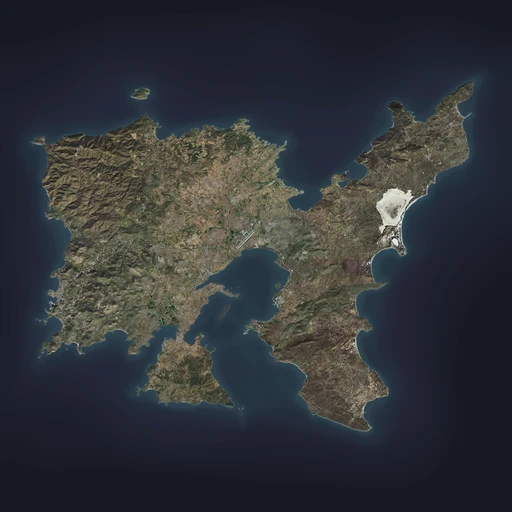
| « | Clocking-in at 270 km², Altis truly is the star of Arma 3. From expansive cities to rolling hills, from wind farms to solar farms, whether steamrolling your tank across the southern plains, or waging asymmetric warfare from the northern hills, the Altis landscape lends itself to some of the most detailed locales and varied engagements. Official ArmA 3 website
|
» |

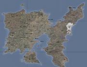
Topographical map with major settlements and POIs labelled
The mainland island of the Republic of Altis and Stratis, Altis as a whole consists of five regions: the East, South-East, Central, West, and the South-West:
- Beginning with the city of Paros, the East goes all the way to the edge of the north-eastern corner of the island.
- The South-East starts at the cities of Rodopoli and Charkia, ending at the south-eastern tip of the island at Feres and Selakano. Pyrgos serves both as the regional and national capital.
- The second smallest region out of the five, the Central section of the island ranges from the village of Kalithea on the eastern edge to the cities of Frini and Athira to the north. Athira serves as the regional capital of the sector.
- The largest of the regions (landmass-wise), the border for the West begins at the city of Zaros to the south and ranges through to the cities bordering the central region; Poliakko and Neochori on the east, up to the village of Ifestiona in the north. Kavala serves as the region's capital.
- The smallest region, the South-West only consists of remote villages and is mostly surrounded by water. It begins at the small strip of land running along the south of the western region's border, which connects it to the mainland at Drimea.
Every single region (except for the South-West) is connected via three main highways that run through each of them: one for the West and Central regions, another for the East, and a third for the South-East.
The South-West region can be accessed via a small dirt road which is linked to an arterial road that splits off from the main western highway.
Geography

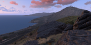
Rocky hills and steep valleys are a common sight all across Altis
Covering an area of 270.5 square kilometres, Altis is a volcanic island with a corrugated and mostly rocky landscape. Scattered throughout the more remote regions of the archipelago are large pine forests and the occasional outcrop of tree groves. A tiny desert also exists north of the village of Abdera and is unique for its micro-environment condition.
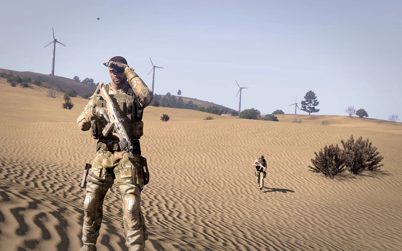
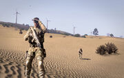
The mini desert north of Abdera
The length of Altis' coastline extends well over 200 kilometres, with a total of twenty bays that surround it as well. The largest of them, the Gulf of Pyrgos, is located in the central sector and partially divides both halves of the island.
Three inland bodies of water, Limni, Ochrolimni, and Almyra also exist. Periodically inundated and flooded in all seasons except for summer, they are entirely saltwater-based. During the summer, the cracked surfaces become completely hard and dry.
The highest point on the island is located at the peak of Thronos at the north-western section of Altis (near the abandoned village of Oreokastro). Measured at a height of 350 metres above sea level, the ruins of a castle built by Arabian warlords during the Middle Ages remain on top of it.
Settlements
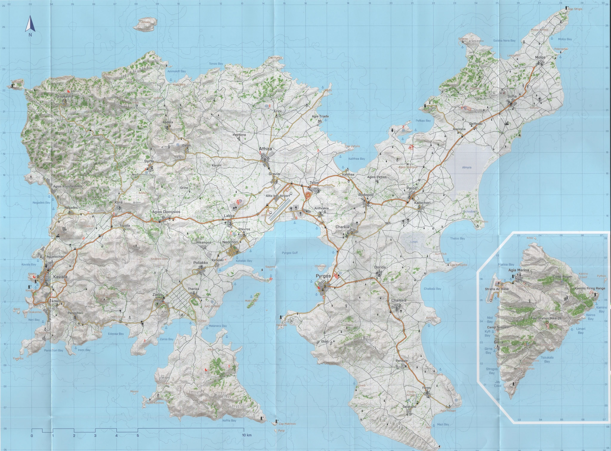
Simplified topographic map with major roads displayed
Including all cities, towns, and villages, there are a grand total of forty nine settlements established on Altis. Of these, twenty two are considered to be major cities. One of them, Pyrgos, is established as the capital city of the nation.
Aside from the larger cities, twenty seven villages/towns are scattered throughout each sector of the island. Numerous military installations and outposts are also littered throughout Altis, usually distinguished by their tall observation towers and research domes.
Up to one hundred and sixty five chapels are present on Altis, with many more being roadside/hilltop Greek Orthodox shrines. The chapel located atop Agia Stemma (a mountain in the eastern region) is particularly notable for its hard-to-access but great viewing position.
East
Delfinaki is a small village built along the main eastern highway. A road just on its eastern limit connects it to the military base built above the hilltop cresting Delfinaki itself (to the north).
- Main article: Ioannina
Less than a few hundred metres to the south-west of Delfinaki, Ioannina is another small village that is built along a stretch of road connected to the eastern highway.
It has a gas station built right next to the main road. The smaller road that Ioannina is built at ultimately terminates at the Temple of Iraklia ruins to the north-west, which overlooks Pefkas Bay.
- Main article: Kalochori
One of the twin cities in the East that borders the southern region, Kalochori is located directly south of Paros' city centre. A church is built near the centre of Kalochori.
Several smaller dirt roads link to the Limni and Ochrolimni saltwater lakes/marshes in the south and east (respectively). One road in the east diverts to Cap Thelos, which contains a church. Another to the south (and east of Limni) links to the Surf Club and Cap Kategidis, which are both coasted along Thelos Bay.
Located on the north-easternmost corner of the island, Molos is the final city after Sofia that the main highway connects to and terminates at.
A small dirt road to the east links it to Polemistia which can be used to access the Molos Bay, while other roads can be used to reach the Molos Airfield to the north. One road also connects Molos to Limnichori (to the west), which is coasted to the Galana Nera Bay.
A city built on the regional border with the South, Paros is a twin city of Kalochori just to its south.
The main eastern highway runs through Paros, and the city itself has a gas station built on its city limits (at the south-west). A dirt road connects it to Agios Georgios in the north which ultimately ends at the Amphitheater ruins overlooking Pefkas Bay (an unmarked weapons research facility is also present along the way). Meanwhile, a smaller eastern road diverts to Kalochori instead.
Built on the north-eastern corner of the island, Sofia is the second last city in the East. The main highway runs through the city centre, with a military facility (complete with radar dome) also built above the hill overlooking Sofia a few metres to the north.
A gas station is present in the city centre along with a church. Two roads connect Sofia to Gatolia in the east, which serves as a power station for a large solar farm just on its outskirts.
South-East
- Main article: Chalkeia
One of the larger settlements in the South-East, the city of Chalkeia is built along the main southern highway.
Notable for being built in the centre of three large hills, Chalkeia's terrain is terraced while the city itself contains two churches and a gas station. Two roads on the east side can be used to reach Chalkeia Bay, while another can be used to reach the ancient ruins at Aktinarki (which overlooks the bay).
Due to the recent years of global climate change, the beaches along Chalkeia's coast are an especially popular destination for surfers around the world as it provides some of the best waves in the central Mediterranean.
Built along two arterial roads in the north, Charkia is one of the larger cities bordered to Central Altis.
Two churches are built in the city. It forms a terminus where the arterial roads from Rodopoli to the north-east and the village of Nifi intersect. The arterial road from Rodopoli reroutes back-and-forth from the eastern and southern main highways.
- Main article: Dorida
Located due east of the capital Pyrgos, Dorida is a large town that contains a church and is built along the main southern highway.
Two large hills are crested to the south which the main highway cuts through. It links directly to the city of Charkia, while smaller roads (intermeshed with open fields) connect to the Limni saltwater marsh to the north-east.
The city of Feres forms the terminus of the main southern highway.
A church is located in the centre of the city, while two alternate roads link it to the village of Selakano in the south-west and church at Agia Pelagia to the south-east. The road to Agia Pelagia can also be used to gain access to the Mazi Bay.
The Feres Airfield is located just left of the city centre, and consists of a few concrete buildings and a dirt-based runway. A gas station is also built just next to the road linking Feres to Selakano.
The first city located along the bottom-half of the South-East region, Panagia is built along the main southern highway.
Two dirt roads from both the city itself and the northern branch of the highway can be used to reach the hilltop wind generator farms above the hilltops to Panagia's north-west. Another dirt road east of the city centre, link it to the wind farms east of it instead. A fourth dirt road can be used to access the remote fishing village of Livadi to its south-west.
- Main article: Pyrgos
The capital of the Republic of Altis and Stratis, Pyrgos is one of the most densely populated settlements on the mainland (after Kavala in the West).
A gas station is located to the south of the city's limits. Two military installations are built near the city itself; one in the north-east and another in the south. A small road links it to the remote hilltop village of Faronaki to the south-west, while the main southern highway (north) can be used to reach Chelonisi Island.
A dirt road that diverts from the road to Faronaki can be used to reach the remote village of Ekali due south of Pyrgos. The entire city meanwhile, is coasted to the Gulf of Pyrgos and has a large promenade/harbour that runs along the length of its beaches.
The remains of the ancient Pyrgos Castle can be found between the harbour and the nearby government office complexes, which serves a particularly popular tourism attraction for the city.
The northernmost city of Rodopoli is built along the main highway that links to the East.
A church is built close to the city's centre. The small village of Agios Petros can be accessed via a road to the north, while an arterial road links it to the city of Charkia just slightly to the south-west.
- Main article: Selakano
A small village south-west of Feres, Selakano is the furthermost settlement located on the south-eastern peninsula of Altis.
A dirt road links Selakano to the Mazi harbour to the south-east, which can be used to access the Mazi Bay itself. The north-western dirt road can be used to reach the Livadi fishing village to Selakano's north-west (connected to via the city of Panagia).
Central
Located to the south-east of the Altis International Airport, the village of Anthrakia borders the South-East region.
There are two churches built in the village, and is actually constructed along a small road that breaks off from the main southern highway. The village has a small harbour to its south that is coasted to the Gulf of Pyrgos. Dirt roads on the east and north can be used to reach the cities of Rodopoli and Telos (respectively).
Located due north of the Altis International Airport, the city of Athira is one of the Central region's largest settlements. It is situated along the border of the western side of Altis, and is also considered to be the capital of the Central region.
A gas station exists on the southern route of the road that links it to Gravia, while a church is constructed in the city centre. Athira forms a terminus where the roads from the city of Frini (north of Athira) and the village of Koroni (to the west) intersect. The village of Ifestiona (in the north-west) can also be reached via another dirt road extended on the city's north.
A large industrial factory/depot is built on the city's limits to its east. The tip of the Central region can be reached via another road that breaks off from the route to Frini to Nychi. The fishing village of Agia Triada (also located to the north-east) can be accessed via a dirt road that extends directly from Athira's city centre.
Lastly, a small military outpost is constructed inside Athira, though it is closed-off from the surrounding civilian structures.
Located even further north of the Altis International Airport, the city of Frini is a settlement that is built along the border with the western region.
The secondary road that extends from Athira terminates at Frini. A military outpost is constructed just to Frini's north-west, while a large pine forest is situated at the city's north. Both can be accessed via smaller dirt roads that extend towards both locations.
The city of Gravia is built along two arterial roads that split off from cities of Lakka (to the south-west), Telos (to the east), and Athira (to the north).
A gas station is set up close to the intersection that leads to Gravia (on the eastern side of the main western highway), while a church is also built in the city centre. The Altis International Airport can be accessed via the highway due south of Gravia itself, with one small dirt road also leading straight to the main terminal. Meanwhile, the large industrial harbour used by the airport is present just to Gravia's south. It is coasted to the Gulf of Pyrgos.
The small village of Kalithea is located due east of Telos, and sits on the border with the southern region of the island.
A relatively tiny fishing village, Kalithea is used to access the Kalithea Bay itself. A church is constructed in the centre of the village, as is a small harbour. The village itself is built along a small road that breaks off from the main eastern highway.
The "Monument of Kalithea" is also notable for being built in the village. It commemorates an old legend pertaining to Altis' recent past.
The city of Telos is located due east of the Altis International Airport.
Telos is built along the main eastern highway which runs through it. One gas station is constructed on the crossroads to the west (near the airport) that splits between the southern and eastern highways, while two churches are also present in the city itself. A major military research facility is also built on Telos' outskirts (directly to the south).
West
Abdera is a mountain village located to the north-east of Syrta.
Constructed in-between a valley separated by mountains on all sides, Abdera is a remote village with only a single paved road linking it to any other major settlement besides Galati to its south.
A stretch of road heading north passes by a small rough surface airstrip along the way to the harbour at Krya Nera further down the valley. Krya Nera itself is coasted to the Ammolofi Bay.
A tiny village located on the northern outskirts of Kavala, Aggelochori mainly serves to mark the limits of the former capital.
Lined with hilly terrain, Aggelochori mostly consists of a few clustered civilian houses with a soccer field placed in-between. A small rock path on the western side leads directly to an enclosed beach below it. The main road that cuts through it (originating from Kavala) links directly to Negades to the north.
Agios Dionysios is a city located directly in the middle of the western region.
Built along the main western highway, Agios Dionysios is one of the bigger settlements in the region. It is situated above a fairly large valley, is south-west of the village of Orino, is due west of Lakka, and is north-west of the town of Alikampos.
Agios Dionysios has a gas station located on the western side of the city while a church is on its eastern side. One dirt roads in the south leads to the Xirolimni Dam due south of the city, whereas another will lead to the factory complex/junkyard just on the city's south-eastern limits. The same dirt road can also be used to reach Alikampos and runs through several more hills.
Road travellers are advised to slow down on the western end of the city, as a U-shaped bend breaks the highway and can cause potential traffic accidents at high speeds.
Agios Konstantinos is a coastal village located due north of Negades.
Situated right next to the Negades Bay, Agios Konstantinos has two harbours situated along its rocky beach. The main road that links Agios Konstantinos from Negades (terminating here) has a small dirt road that extends from the north-western tip, which connects it to the remote settlement of Fotia further north-west.
Agios Konstantinos is notable for its picturesque chapel that resides on the rocky promontory overlooking both the sea and Negades Bay. It is believed to have been constructed over the ruins of a much older antique temple.
- Main article: Alikampos
Alikampos is a small town located between Neochori and Poliakko.
It is linked via three small roads extending from Neochori to the east and Katalaki to the south. The third road in the north can be used to reach Agios Dionysios to the north-west instead. The only notable location is a construction site/village that is slightly separated from the main town itself. There are otherwise no other distinguishing landmarks in the town.
Edessa is a small village located in-between the city of Zaros to the east and the bigger village of Panochori to the west.
Comprising of scattered houses and unfinished buildings littered along the arterial road linking directly to Kavala, Edessa is a mostly unremarkable settlement. A bridge on the eastern side of the village is built over a small creek that empties out into the Edessa Bay.
Meanwhile, a dirt road on the western side can be used to reach the hilltop settlement of Edoris, which also has a military outpost constructed nearby that overlooks the bay.
Situated at the base of a mountain, the village of Galati is located to the north-west of Koroni and north-east of Syrta.
A church is built at the centre of the village. A road connects it directly to the village of Abdera to its north-west. Two small military outposts (complete with a helipad) are established on the mountaintops overlooking Galati.
- Main article: Ifestiona
The village of Ifestiona is located north-west of Athira.
Characterised by its hilly and rocky surroundings, Ifestiona has several dirt roads that link it to Frini in the north-east and through the enormous mountain valleys to the west. Because of this, it mostly serves as a "gateway" through these valleys to Krya Nera further north-west, as well as to the mountain villages of Abdera and Galati (both due west).
A slum/shanty town situated in-between the cities of Poliakko and Nechori.
Katalaki is "built" along a road that stretches between the two cities. It is coasted along a small inlet leading to the Katalaki Bay, which itself extends to the Gulf of Pyrgos. A dirt road to the south can be used to access the small naval port south-east of Katalaki, which can be used to traverse to the islands of Sagonisi (north) or Makrynisi (south).
Kalalaki does not have any landmarks save for a few civilian dwellings, though a gas station is set up just further north up the road leading into Neochori. The rest of the "town" actually consists of corrugated iron shacks and other forms of improvised housing for refugees.
- Main article: Kavala
The former capital city of the country, Kavala is one the biggest and most heavily-populated (if not the largest) city on the Altian mainland. It serves as the regional capital of the West region.
Two gas stations are built in the city; one along a road that breaks off the main western highway in the south, and another in the northern district of the city. Four churches are also present and are scattered throughout all sides of the city. The country's largest civilian hospital is also built in Kavala, with several government offices dating back to its days as the capital city also present near the city centre.
The main western highway loops around and runs directly through Kavala, with many more arterial roads linking the villages of Aggelochori and Panochori to the north and south-east (respectively), and also another to the cities of Neri due south of Kavala.
Kavala was founded by Venetian merchants on the ruins of an ancient Phoenician city, and served the Republic's capital for several centuries before its status was revoked. Since then, it has remained as one of the most densely populated settlements on the island.
Because of its rich cultural history and unique surroundings, there are three "hot spots" in the city itself. This includes:
- Old Kavala: Built by the Ancient Phoenicians, this fortress-like structure is located in Kastro; the western district of the city. A lighthouse is built just below it and overlooks the main harbour.
- Kavala Bay: Pristine beaches run along the coast of the city's north-western district (close to the village of Aggelochori). Especially popular with amateur fishermen, beach-goers, as well as diving enthusiasts.
- Kavala Pier: A large harbour stretches along the south-western district of the city. This harbour serves as a major entry point for domestic and international shipping import/exports.
Located due north of Topolia, the city of Kore is built in-between two valleys.
Kore is linked via two roads that extend out from it. One heads in the direction of Syrta to the north-east, while another branches off to the remote mountain village of Oreokastro to the north-west. The third route goes west directly towards the village of Negades.
A church is present in the city's centre, as well as a small military outpost constructed on the city's limits in the south-west next to the main western highway. A large factory complex is also situated along the road to Negades west of the city.
A tiny village between Galati to the west and Athira to the east, Koroni serves as a "stopping point" for the strip of road in both directions.
Mostly devoid of structures besides a few civilian houses, Koroni is actually built separately from the road that links it between the two villages/cities. Dirt roads separate from the main road lead back to Athira, Orino in the south-west, as well as Lakka to the south-east.
A moderately-sized town, Lakka is situated due north of Neochori and Stavros.
The town mostly consists of tightly-packed civilian dwellings mixed with a few warehouses and soccer fields. A gas station is also positioned on the western side of the town along the main highway that cuts through the town centre.
Furthermore, a military outpost is also set up on the nearby hill (north of the town) and overlooks the entire area. It can be accessed via the arterial road that links Lakka to the city of Gravia to the north-east.
- Main article: Oreokastro
Oreokastro is a mountain village located in the far north-westernmost section of the island.
The origin of its naming is a portmanteau of two words from the native Altian language: "oreo" and "kastro", which combines to form "beautiful castle" in English.
Temporarily abandoned in the aftermath of the civil war and then populated again following its resolution (and then abandoned once more), Oreokastro was mostly isolated from all other settlements on the island. Though remote, its nearby castle ruins was also a tourism destination as well.
The castle, which was built during the days of the Ancient Roman Empire, was attacked by the Roman Army for almost six years during the First Punic War in an attempt to dislodge its Phoenician defenders (who constructed the castle initially). Sometime later during the ninth century, the ruins were occupied and built over by Arabian warlords but was also eventually abandoned, leaving it in its current state.
Like its turbulent ancient history, control of the present day village has changed hands several times between anti-government guerillas and the government itself. It was eventually abandoned for good after its complete destruction, with only burnt-out and condemned buildings, as well as the partially-destroyed church remaining.
A village built directly in-between two valleys, Negades is located further north of Aggelochori and due west of Kore.
A church is built inside the village. Two side roads intersect at Negades; one from Aggelochori itself and another from Kore. A large civilian communications facility is constructed on the hilltop due south of the village, while the sports Stadium is situated below the hill to the south-east instead.
Neri is a small city located to the south of Kavala.
Established in between two mountains, Neri mostly consists of scattered civilian dwellings on its eastern side with densely packed structures along the coastline of Neri Bay. Both the arterial road and main western highway links Neri to Kavala's city centre, while it also links it to the village of Panochori to the south.
Two churches are present in Neri, with a small military outpost set up just north of Neri's city centre. A large harbour also runs along the length of the coast to Neri Bay.
Orino is a a small village located to the north-east of Agios Dionysios.
Surrounded by small forests, Orino only consists of a few civilian homes and small hills that surround it. It is linked to by a small road extending straight from Agios Dionysios.
Panochori is a large village constructed in the middle of a valley.
Located south-west of Neri, Panochori mostly consists of scattered homes with a church located in the centre. It is built along the arterial road that cuts through Edessa to the east. Dirt roads leading south from Panochori can be used to access its beaches and harbour; Iremi Bay on the south-eastern side and Panochori Bay on the south-western side.
The mountain cave chapel of Agios Panagiotis directly north-east of Panochori is a popular destination for religious pilgrimages and festivities, both local and abroad.
Poliakko is a small town located due south of Alikampos and north of Therisa.
A small-sized town, Poliakko has a church and civilian houses tightly intermeshed with each other. It is otherwise fairly unremarkable and lacks any other distinguishing landmarks.
A small town located north-east of Neochori and south-east of Lakka, Stavros runs along the border with the Central region.
Consisting mostly of several unfinished buildings, a church, and several homes, there isn't anything remarkable about Stavros. It is connected to the other two locations via a small arterial road that splits off from the main western highway.
- Main article: Syrta
Located north-west of Kore and south-west of Abdera and Galati, the town of Syrta is situated south of the hillside forests to its north-west.
Syrta has a gas station built inside it. A government outpost is constructed overlooking the city along the western half of Syrta, along with a helipad reserved for military use. The mountaintop village of Amfissa can be accessed via dirt roads leading south of Syrta itself. The main road that runs through the town can be used to get to either Galati (north-west) or Kore (south-east).
Therisa is a medium-sized town situated north of Drimea, south of Poliakko, and due east of Zaros.
Slightly larger than Poliakko, Therisa similarly features tightly compacted civilian dwellings intermeshed with a church in its centre. A small dirt road can be used to reach the AAC Airfield located to the south-east which is coasted to the Melanera Bay.
Large open fields are located west of the town that runs all the way to the city of Zaros. The fields are divided up in a grid layout by smaller dirt roads, while two large hills overlook the town from the north and south (the southern hill is covered in forest).
Topolia is a tiny village located south of Kore.
Linked by a small road that breaks off-and-back onto the main western highway, Topilia is situated between a large hill to its north (south of Kore) the mountain of Agia Stemma to the south.
Zaros is a city located along the regional border with the south-western section of the island.
Often referred to as the "Pine City", Zaros is built right in the middle of large pine groves that surround it on all sides. It is situated beneath two large hills, and is connected via two arterial roads from Poliakko in the north-east (and Edessa due west) while another comes from Drimea to the south-east. A third route (that ends in a dirt road) can be taken to reach a small harbour coasted to the Zaros Bay.
Zaros has two particularly notable landmarks present; the chapel overlooking the city itself which provides access to some of the nicest vantage points in the area, the other being the large windmill above the hilltop of Riga just south of the town.
South-West
A small village that borders the western sectors of the island with Zaros, Drimea mainly serves as the "gateway" into the South-West region.
Literally situated on the T-shaped road intersection that links Therisa with Zaros, Drimea has no real distinguishing landmarks aside from its small harbours on the western (an inlet leading into the Zaros Bay) and eastern sides (Melanera Bay). The dirt road on the southern end of the intersection is what leads into the south-western region.
- Main article: Eginio
Eginio is a remote settlement located at the centre/bottom-half of the South-West.
Largely identified by the wind generator farms that surround it above the hills on all sides, Eginio only consists of a few scattered civilian houses built along both sides of the valley, which also leads into the Naftia Bay in the south.
- Main article: Sfaka
Sfaka is a remote settlement located south-west of Drimea.
Built at the base of the Agela mountain, Sfaka only consists of a few civilian homes with a few wind generator farms constructed on the mountaintop. Both the hilltop chapel and tip of the island, Agios Kosmas, can be reached via the dirt road extending out from Sfaka by car or on foot. Meanwhile the island of Monisi (west of Sfaka) can only be reached via boat.
- Main article: Vikos
Vikos is a remote settlement based in the south-east of Drimea.
Consisting of only a few scattered civilian homes, Vikos is located not too far from Drimea itself. It is set up below two mountains which have a military outpost and the ruins of an ancient fortification on the east and west mountaintops, respectively.
A thick forest divides the two mountains with a dirt road cutting through it and leading south towards Eginio. It is also coasted to Melanera Bay in the north, though only partially.
Points of interest
- Main article: Altis Aero Club Airfield
The Altis Aero Club airfield is a small dirt airstrip located near the city of Therisa.
First built in 1916, the AAC was one of the very first airfields built on Altis during its days as a colonial subject of the British Empire. Since then, it has been retained for civilian recreational use, though it has also served as rudimentary forward airbase for both NATO forces and AAF.
The mountaintop of Agia Stemma, south of Topolia, provides great views of the entire island in all directions. It is very difficult to access both on foot and by vehicle due to its steep terrain inclines however, so air transportation is preferred.
- Main article: Altis International Airport
Located directly in the centre of the island (specifically the Central region), the Altis International Airport is the main hub from which civilian air travellers and commercial freight arrive and depart from.
It has two major runways which link to a main passenger terminal in the centre of the airport. Non-hardened hangars are set up on the western side of the airport, and are mainly reserved for military aircraft instead. A large radar dome is set up here, with a control tower located in the middle between the two areas as well.
A Go-kart racing track is set up along the main western highway close to the military portion of the airport, which also includes a gas station. A small barracks with a fuel depot is also present on the eastern side of the airport.
Lastly, an industrial yard full of shipping cargo containers is located directly to the south of the airport. This is connected to a harbour that is coasted to the Gulf of Pyrgos.
Isolated from the rest of the mainland, the northern island of Atsalis is defined by a small mountain that is completely surrounded by the sea.
A strip of arid land completely devoid of any flora.
This "desert" is unique for its terrain that is not available anywhere else on the Altian mainland. Unlike the dried up saltwater lake of Almyra, this micro-environment features rolling sand dunes instead of the usual bare/grassy knolls scattered throughout the island.
Located along the northern coastline on the eastern regions of the island near the city of Sofia, this abandoned resort has several dilapidated buildings scattered around the nearby forest.
Gallery
") ") ") ") ") ") ") ") ") ") ") ") ") ") ") |
Amsterdam
NOTE:
- The Amsterdam "terrain" is featured exclusively for the Art of War DLC's Art of War exhibition/showcase gallery.
- It is not a standalone, fully playable terrain of its own.
- The "terrain" is merely fabricated out of editor props/structures on the dried lake of Altis' Almyra with a layer of trimmed grass placed on the ground to simulate a "clean" surface texture.
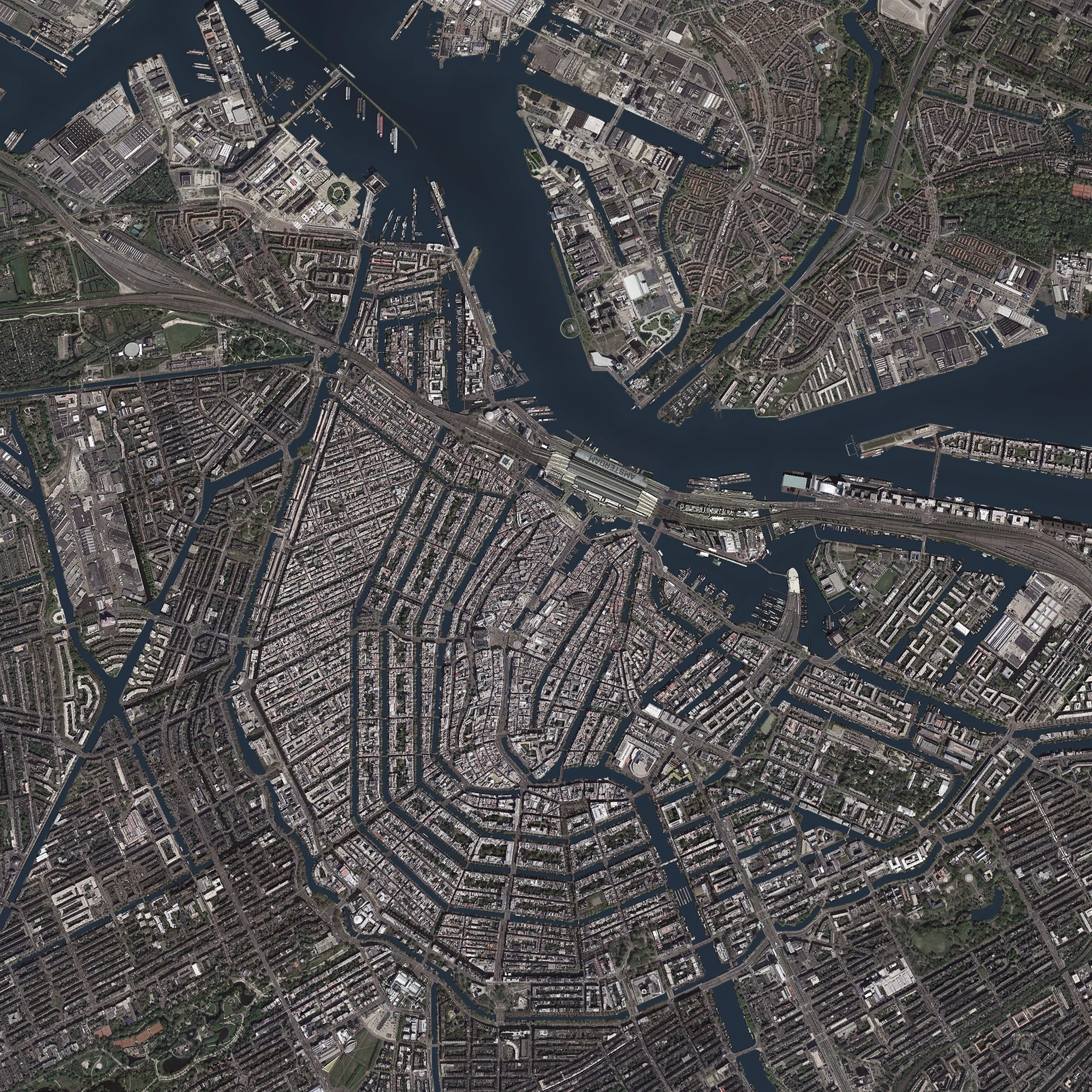
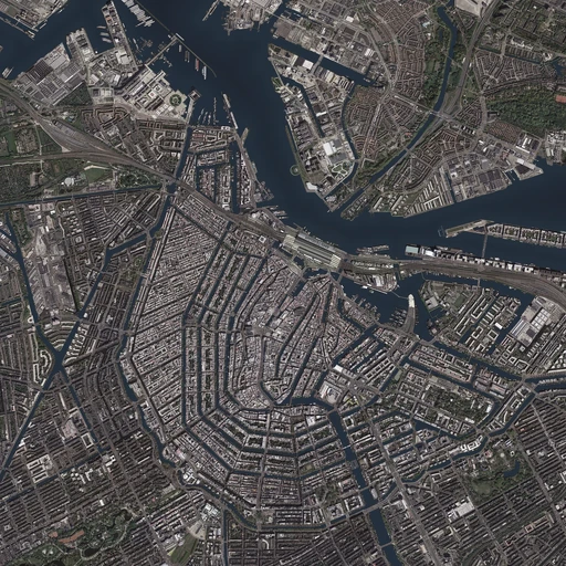
| « | Time for a little R&R - and a visit to Amsterdam's Lars Blanken Gallery. The current collection, displayed as the 2035 Art of War exhibition, features award-winning works from an eclectic mix of international artists. Some you may know, others you may not. These creators for charity, who have generously donated their works to raise money for victims of armed conflict, come from a range of different backgrounds and professions, allowing us to present important themes through a kaleidoscopic lens, colored by diverse views and cultural perspectives. Art of War exhibition description
|
» |
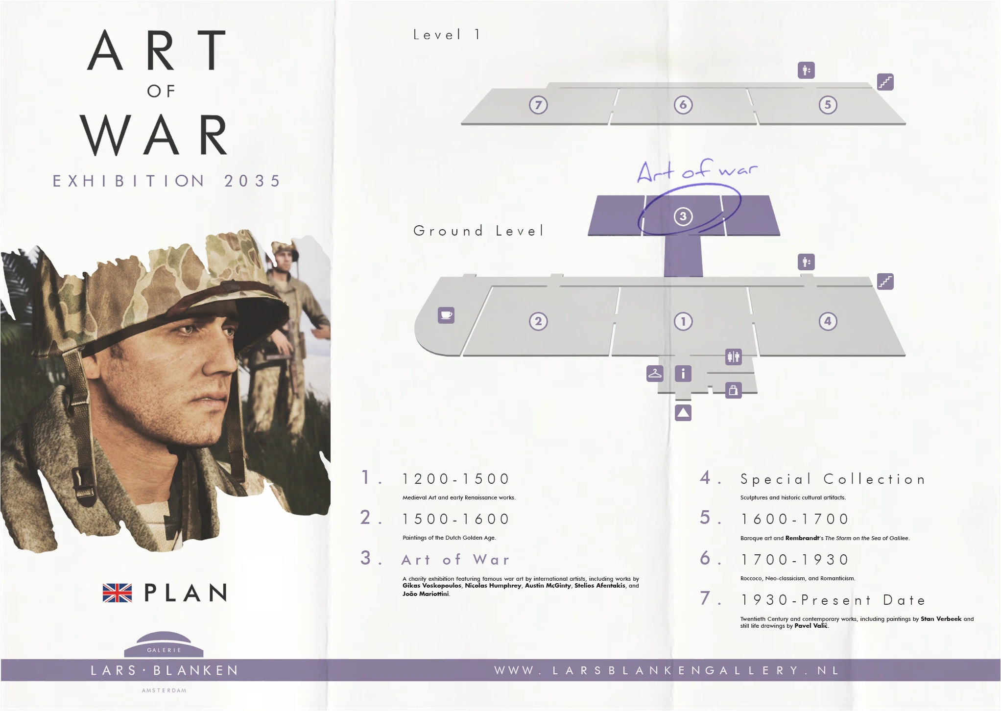

Gallery floor plan.
The Lars Blanken Gallery - Amsterdam's famous museum of fine arts, is named after Lars Blanken, a Dutch philanthropist and founder of the Non-Government Organisation, the International Development & Aid Project.
Visitors to the gallery can see the numerous artworks on display, gifted by artists of various backgrounds, to raise money for victims of conflicts throughout the globe.
They can also take the opportunity to learn about the relevance of International Humanitarian Law (IHL), and the future of warfare and its potential implications on armed conflict between humans.
Trivia
- Altis is directly based on the real-world Greek island of Lemnos in the Aegean Sea.
- The in-game island is approximately 25% smaller than its real counterpart however, both for design and engine reasons.
- Its total landmass is slightly smaller than twice the size of Washington, D.C, the capital city of the United States.
- Altis was not included during the Alpha build of ArmA 3 and was only made available late into the Beta's release (at the same time of the full game's launch).
- Properly enterable buildings for the Ghost Hotel and the Stadium itself were not added until the release of Game Update 1.14 as part of the main campaign's third episode.
- Other minor updates included the addition of small kiosks and other miscellaneous objects to enhance Altis' visual variety.
- Prior to ArmA 3's major development overhaul in 2012, Altis was previously known as "Limnos" instead.
- Many cities were also named differently and were mostly identical to their counterparts on real-world Lemnos, such as the city of Kavala being called "Myrina" and its bay "Myrina Bay". All were eventually changed to their final versions following the design shuffle.
- Some maps (including one found at the FIA camp in Gori) still bear towns that have the original Limnos names. For example, Kavala is marked as Myrina and Oreokastro is completely nonexistent. However, strangely enough, the map does say it is "Altis Island" in the lower right hand corner, implying at some point in development, the island was named Altis but all the towns were still named normally.
- It is the biggest official terrain in the series to date, with only its Chernarussian predecessor in ArmA 2 following closely behind in second place.
External links
See also
| Playable terrains in ArmA 3 | |
|---|---|
| Official Terrains | Altis (Amsterdam) • Livonia • Malden • Stratis • Tanoa • Virtual Reality |
| Third Party Terrains | Cam Lao Nam • Gabreta • Khe Sanh • Normandy • Sefrou-Ramal • "The Bra" • Weferlingen |
| Official DLC: Apex DLC | Contact DLC Creator DLC: CSLA Iron Curtain | Global Mobilization - Cold War Germany | S.O.G. Prairie Fire | Spearhead 1944 | Western Sahara | |