(Completed article.) |
m (→Trivia) |
||
| (One intermediate revision by the same user not shown) | |||
| Line 10: | Line 10: | ||
== Geography == |
== Geography == |
||
| − | [[File:OFP-terrain-everon-03.png|thumb|right| |
+ | [[File:OFP-terrain-everon-03.png|thumb|right|Everon's mountain valleys are typically covered with dense forests]] |
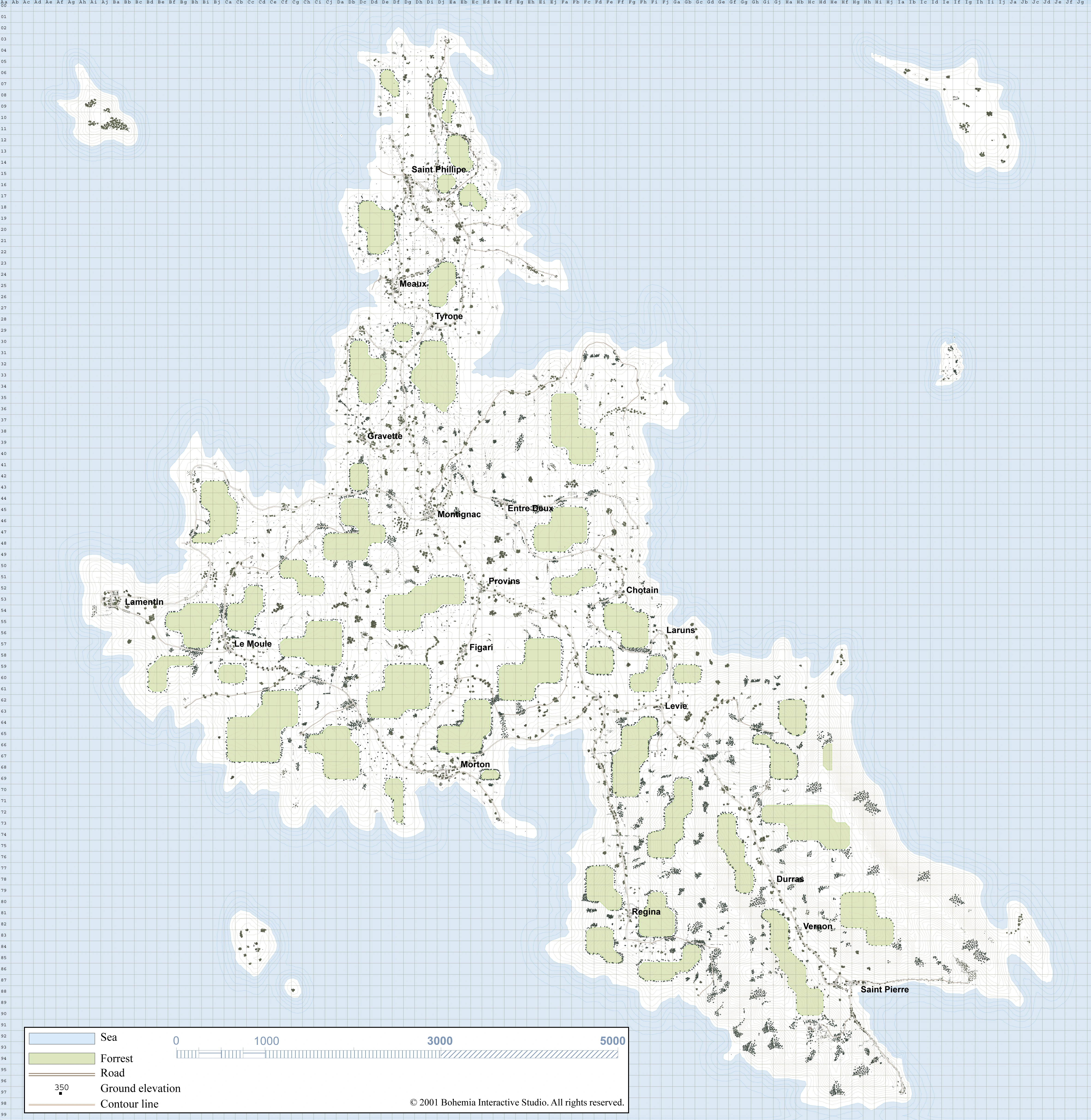
Covering an area of 51 square kilometres (including the isolated mini-islands around it), Everon's terrain is mostly flat pasture ground with the occasional outcrop of sloped, rocky hills. |
Covering an area of 51 square kilometres (including the isolated mini-islands around it), Everon's terrain is mostly flat pasture ground with the occasional outcrop of sloped, rocky hills. |
||
| Line 162: | Line 162: | ||
== Trivia == |
== Trivia == |
||
| − | * Everon's landscape is |
+ | * Everon's landscape is inspired by the Croatian island of Krk located in the northern Adriatic Sea, though the in-game counterpart is obviously much smaller than its real counterpart. |
== External links == |
== External links == |
||
Revision as of 15:49, 23 December 2018
|
NOTE: This article is about the Everon terrain in ArmA: Cold War Assault. For the country of the same name, see Everon. |
Everon is a playable terrain in ArmA: Cold War Assault.
Overview
One of the three main islands in the Malden islands chain, Everon serves as the micronation's homeland and is the second largest landmass amongst the three islands.
Everon's architecture is heavily influenced by French designs; a remnant of its long-standing heritage of being a French territory during the colonial periods in the early 19th century. Even after its takeover by the Prussian Empire and subsequently, Nazi Germany, little has changed over the centuries, with Everon remaining as a quiet and relaxing island.
Geography
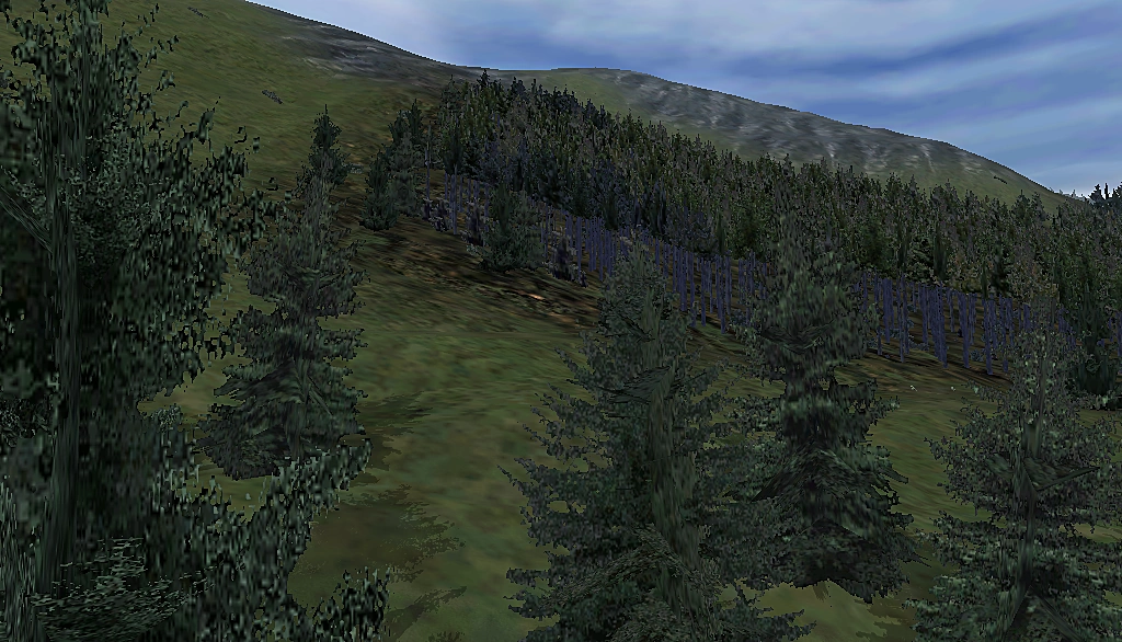
Everon's mountain valleys are typically covered with dense forests
Covering an area of 51 square kilometres (including the isolated mini-islands around it), Everon's terrain is mostly flat pasture ground with the occasional outcrop of sloped, rocky hills.
Most of the landscape is covered in thick woodland consisting of oak, birch, chestnut, and beech trees, while the larger forests consist exclusively of pines. On the other hand, the forests situated on Everon's hills and valley peaks mostly consist of sparsely-grown spruces instead.
Everon's shoreline is indented with a number of sandy beaches and a few rock formations that cut into the sea (mostly on its south-eastern coast). Everon does not have any inland bodies of water.
The south-eastern section of the island is where the majority of Everon's taller peaks are located. While Everon does not have any particularly tall mountains, the highest position on the island is located on top of the valley between the villages of Regina and Durras, which has an elevation of 358 metres above sea level at its peak.
Settlements
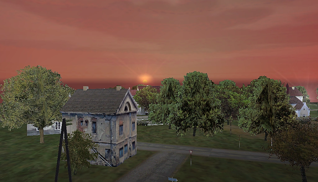
The village of Lamentin at sunset
Everon has a total of eighteen villages and towns scattered throughout the entire island. Owing to the lack of an established government authority, there is no defined capital city on the island.
However, the towns of Montignac and Saint Pierre can be considered to be its most populated settlements and therefore, as its "capitals".
Most of the smaller villages only consist of clumped-up civilian dwellings and farms, with the occasional church and manor built alongside them. Most of Everon's established settlements are linked together, though many are basic single-lane gravel roads and dirt trails/tracks.
Towns
Montignac is one of the largest, most populated towns on the island and is located in the central part of Everon.
Heavily built-up; at least compared to the standards of settlements elsewhere on the island, Montignac is constructed at the centre of an open plain. The village of Entre Deux is situated due east of Montignac, while the two other villages of Provins and Gravette can be reached via roads that split off to the south and north-west (respectively).
Montignac is built right in the middle of a crossroads that connects the northern peninsula to the rest of Everon. Due to its unique position, the town holds a somewhat significant importance for logistical purposes, and acts as a pit stop for travellers hoping to reach the other parts of the island.One of the largest towns on the island, Saint Pierre is a coastal settlement located on the south-eastern tip of the island.
Because it is constructed in the middle of a mountain valley, there is only one road that leads directly into Saint Pierre from the village of Vernon (to the north-west). All of Saint Pierre's dwellings are concentrated along this road, with the pub overlooking the beach perhaps being one of its notable landmarks.
Saint Pierre also serves as one of the major entry points onto the island via the sea. There isn't an actual harbour built at the beach for vessels to dock at, though the gravel road which runs through Saint Pierre itself terminates directly at the shore. This ensures easy access to and from the coast for any ships attempting to make a stopover.
At the height of the Cold War, Saint Pierre was also somewhat known for serving as the headquarters of the Soviet Union during Everon's brief occupation. It was eventually razed to the ground by NATO forces following the town's liberation.Villages
Located just a short distance north of Laruns, Chotain is the second of the two coastal villages on Everon's east.
Chotain is linked by a road that originates at Levie further down south, and ultimately terminates at the village of Entre Deux to its north-west. The village itself is mostly surrounded by the nearby forests and has access to a beach to the east.
Unlike Laruns, the beach at Chotains is smaller and is slightly more difficult to access owing to the steep inclines. Similarly, there is no path that can be taken to reach it either.Durras is a small village built at the mouth of a valley in the island's south-east.
Essentially forming the "gateway" to the mountainous south-eastern area, Durras is built along the road that leads straight towards Vernon and Saint Pierre further ahead. It is completely surrounded by the mountain ridges on either side, as well as dense pine forests that cover the slopes.
The village contains several houses closely packed together, but otherwise features no important landmarks.Entre Deux is a small village located in the island's central region.
Situated above a small plateau due east of Montignac, the village of Entre Deux is built within a small forest. A T-junction runs through the village, and can be used to reach either Montignac itself (to the west) or Chotain to the south-east. A smaller trail can also be taken to access a beach on the eastern side of Everon.
The village itself only consists of a few fenced homes cluttered together at the road intersection. There are no other outstanding landmarks in the village.Figari is a tiny village located in the island central region.
Figari is built along a road that originates from Morton (to the south) and terminates at the village of Provins (to its north).
A relatively nondescript settlement, Figari has a small chapel built directly in the centre. The surrounding buildings only consist of simple homes, with no other landmarks in the village itself.Gravette is a coastal village located in the island's north. Gravette can only be accessed via a small road that breaks off from the route to the village of Tyrone (further north). It consists of a few houses clumped together, but otherwise bears no other notable landmarks.
Lamentin is a village located along the island's far western coastline.
Lamentin can be reached via a long trail that originates from the crossroads at Montignac or the road from Le Moule (both from the east).
Larger than most villages on the island aside from the towns of Montignac and Saint Pierre, Lamentin consists of many smaller houses better known for being a vantage point for tourists visiting the island, and provides a superb view of the sunset in the evenings.Laruns is a tiny village located in the island's far east.
Laruns is connected by a trail that originates at Levie (to its south) and terminates at Entre Deux (further north-west).
Surrounded by forests and the eastern coast, Laruns is relatively nondescript and only consists of only a few houses. A sandy beach can be easily accessed to its north-east, though there is no path that leads to it and the beach itself is situated at the base of a steep slope.Levie is a village located on the island's south-east.
Built near the main road that leads directly into the south-eastern section of Everon, Levie serves as the "true" gateway into the area. It mostly consists of scattered homes and one large farm built on a hill overlooking the road.
While the two coastal villages of Chotain and Laruns (to its north) are actually closer to the "border" zone between the two areas, Levie is established on the T-junction that heads into the south-east.Located on the island's western side, Le Moule is built on the outskirts of Lamentin. Le Moule's structures are built along the roads that leads to Lamentin (further west), and consist predominately of medium-sized homes and a church. There are otherwise no other important landmarks in the village itself.
Meaux is a small village located to the south of Saint Phillipe and north-west of Tyrone. Slightly bigger and more populated than nearby Tyrone (but not by much), the village of Meaux consists of a few homes and church. There is easy access to the shore due to the village being built right next to the western coastline.
A medium-sized village, Morton is located in the island's central region.
The smaller village of Figari can be reached by taking the road that leads north out of Morton, while the roads to the east can be used to reach Levie and the rest of the south-eastern area instead.
Relatively big compared to most other villages in the central region (aside from Montignac), Morton is a coastal village that is built right along the central shore. It provides easy access to the sea, and has a great view of the south-western coastline from the lookout point on a L-shaped outcrop extending from Morton's coast.Provins is a small village located in the island's central region.
Situated just a short distance off to the south-east of Montignac, Provins mostly consists of a few fenced-off homes and a gas station that's built along the road north-west of the village centre (leading to Montignac).
There are otherwise no important landmarks in the village itself. The village of Figari can be reached by taking the southern road leading out of the T-junction in Provins.Regina is a medium-sized village located in the island's south-east.
Like Morton, Regina is quite large compared to most other villages on the island (besides Montignac and Saint Pierre. It can only be reached via the road that connects Levie with Morton.
It is completely surrounded by forests on all sides, with the peak of the tallest point on the island being (partially) accessible via the trail that splits off towards the east.Saint Phillipe is a small village located on the island's peninsula to the north.
Saint Phillipe is connected via two roads that approach from the villages of Meaux and Tyrone directly to its south. A small trail can be taken north to reach the tip of Everon's northern shore.
Established in the middle of four small forests, the village of Saint Phillipe mostly consists of clustered homes built along the road from Meaux, while a few isolated houses are built on the road from Tyrone instead. The trail heading north leads to a small chapel built overlooking Everon's northern edge, and provides a great view of the surrounding coastline and beaches.
Saint Phillipe is perhaps better known for the nearby Airfield, which serves as the only the only airstrip on the island with a paved surface.Tyrone is a tiny settlement located to the south-east of Meaux.
Heading north along the western road will lead to Meaux, while going on the eastern road will head directly to Saint Phillipe instead. On the other hand, the village of Gravette can be reached by heading due south.
Tyrone only consists of a few homes packed tightly together. There are no other landmarks in the village itself, since the village serves as more of a junction to head to either Meaux or Saint Phillipe.Vernon is a tiny village located in the island's south-east. The last stop before reaching the town of Saint Pierre, Vernon is largely unremarkable save for being situated right in-between two mountain ridges. There are otherwise no other important landmarks in the village itself.
Points of interest
Consisting of a few barracks and scattered support structures/depots, the Airfield is Everon's sole airstrip that has a paved runway for domestic and international flights.
Located due south of Saint Pierre at the peak of the mountain, these ruins consists of a gate, two towers (one partially destroyed), as well as the rubble of walls scattered around it.
The castle itself dates back to 19th century, and was presumably built by the Prussian Empire when Everon served as an outpost for the Prussian Navy.
However, the ruins are better known for being the headquarters of the "Everon Freedom Alliance" during the Soviet occupation in the mid-1980s. It continued to serve as a base of operations for the resistance group until the island's liberation by U.S.-led NATO forces.Gallery
")
")
")
")
")
")
Trivia
- Everon's landscape is inspired by the Croatian island of Krk located in the northern Adriatic Sea, though the in-game counterpart is obviously much smaller than its real counterpart.
External links
See also
| Playable terrains in ArmA: Cold War Assault | |
|---|---|
| Desert Island • Everon • Kolgujev • Malden • Nogova* | |
| * denotes terrains that were added in the Resistance expansion pack. | |