Stratis is a playable terrain in ArmA 3.
Overview
| « | With rugged terrain, expansive forests and a man-made airbase, Stratis offers a wealth of opportunities with which to wage war. Take to the skies in an attack helicopter, or fight on foot across this 20 km2, near-future battlefield. The choice is yours. Official ArmA 3 website
|
» |
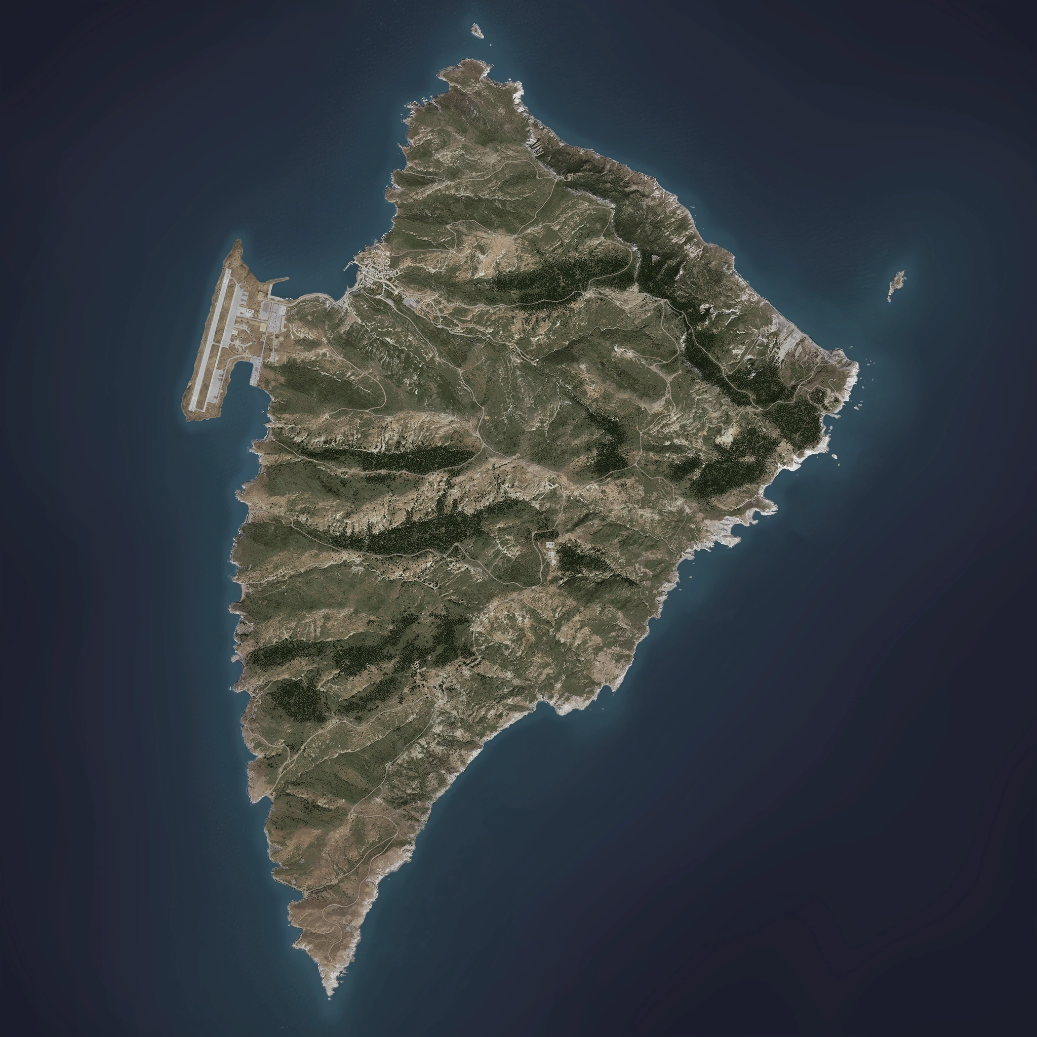
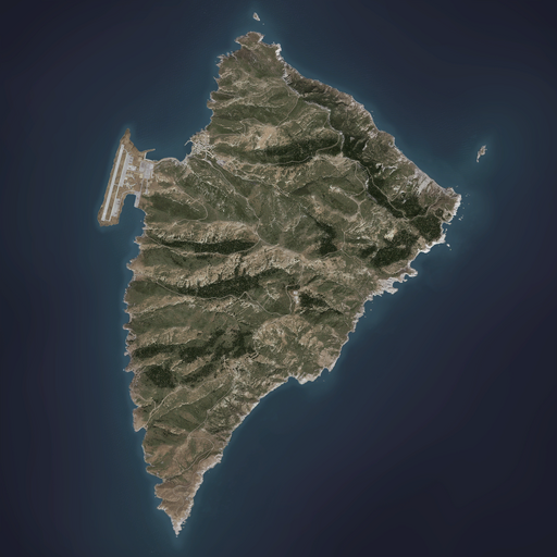
Stratis is the smaller of twin landmasses that when combined together, form the Mediterranean island nation of the Republic of Altis and Stratis. It is located to the south of the mainland, and is a fully-militarised island with no civilian inhabitants.
Geography

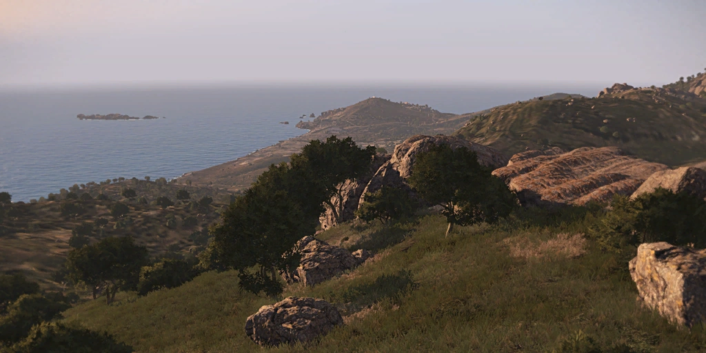
Stratis' landscape typically consists of rocky hills separated by steep valleys
Stratis' landmass covers a total area of only 19.3 square kilometres.
Like the mainland, Stratis is of volcanic origin and its landscape consists of rocky crevices separated by steep valleys, though Stratis features many more pine forests that sprawl across large parts of the island (particularly in its south and east).
Stratis does not have any inland bodies of water. A total of seven bays are dotted along its shoreline - the majority of which are small inlets and coves.
Its geographic coordinates are located between 34° 48' 38.60" north and 16° 23' 49.81" east.
Settlements
Post-civil war, Stratis only features two settlements which are completely derelict and abandoned. No civilians remain on the island, and the majority of its former settlements have been turned into military facilities or camps instead.
Very few paved roads exist for both vehicle/foot travel. The majority of road access across the island are limited to simple dirt tracks, which are connected via a crossroad positioned in the island's centre.
Besides the two main bases of Air Station Mike-26 and the Stratis Airbase, a total of five more installations exist; Camp Tempest, Camp Rogain, Camp Maxwell, LZ Connor, and LZ Baldy. Both Connor and Baldy serve as landing pads for rotary-wing aircraft, while Maxwell has been decommissioned and is no longer utilised by either foreign troops or government forces.
There are a total of two lighthouses present on the island; one built in the northern half (due north of Agia Marina) and another in its southern half.
Towns
Agia Marina was formerly a harbour town located in the island's north-western corner.
It contains the island's only gas station (located to its south along the road leading to the Stratis Airbase) and several abandoned homes. Numerous dirt and unpaved gravel trails/roads lead out of the town to the east and south-east.
Pre-civil war, Agia Marina served as the main gateway into Stratis. It features a large harbour for both international and domestic vessels to dock in, and also contained a small creek which cut through the town itself before terminating at the military base to its south-east.
In the early days of its existence, numerous tall structures were built in the heart of Agia Marina. However, a large earthquake in the 1960s devastated portions of the town and forced the government to reconstruct it. Subsequently, the remnants of the old town were built over with simple residential homes instead.
After the civil war, what was left of its inhabitants were forcibly relocated to the mainland. Ever since then, Agia Marina has remained as a ghost town as all military vessels dock at the Stratis Airbase's own harbour instead.Villages
Girna was a small fishing village built in at the base of a valley on the island's western coast.
Formerly inhabited prior to the civil war, Girna was one of the larger settlements scattered across the island (though not nearly as populated as Agia Marina). It features several abandoned residential homes overlooking the Girna Bay itself, which contains a small underwater reef with picturesque corals and rocky arches.
There are no gas stations built in Girna.Points of interest
- Main article: Air Station Mike-26
Air Station Mike-26 is located in the island's centre.
It consists of a large radar dome and sports several other facilities dedicated to signals intelligence and satellite communications. A dirt road passes through the base and runs through the surrounding hills to the Stratis Airbase (to its west).
Once an important NATO SIGINT facility, Mike-26 has largely fallen into disrepair over the past few years due to the declining importance of the region's security. It was however, the focal point of the fighting between the AAF and NATO forces in 2035 when it was razed to the ground; presumably by government troops.
- Main article: Kamino Firing Range
The Kamino Firing Range is located on the island's far east.
The range itself actually consists of two components: the firing range itself which consist of several military buildings and an obstacle course, and the remnants of the old Kamino village to its north. The two sections are separated by a barren strip of rocky terrain.
The remnants of the old village are mainly used for target practice by government forces. Pre-NATO intervention, the facility was also shared with the peacekeepers of Task Force Aegis. They were supported by a small staff of trainers from the Vrana Corporation, who held competitive shooting/obstacle courses on occasion as well.The Spartan Monument is located in the island's south, and is constructed atop the peak of a small hill overlooking the southern shoreline.
Built in the mid 20th century, the Spartan Monument is dedicated to the thousands of Altian soldiers who gave their lives while serving under the British Empire during the Second World War.
As part of the Allied landings in North Africa (1942), thousands of Altian men were conscripted to take part in Operation Torch. Many of these soldiers never returned from the front lines, and their deaths are now largely attributed to the so-called "lost generation" of Altian history.
- Main article: Stratis Air Base
Formerly operated in conjunction with the peacekeepers of NATO's Task Force Aegis, the Stratis Airbase now serves as a training and logistical facility for government forces.
It is located on the far north-western corner of Stratis, and is an artificially extended part of the island's terrain. Access to the airbase is only possible via a small stretch of road that connects from the town of Agia Marina; due east of the base itself.
The airbase features a single-strip hard surface runway and also contains additional facilities ranging from a barracks, a control tower and radar dome, a hardened bunker, a small military use-only dock, along with a fuel depot. No hardened shelters are available, though several canvas/steel hangars are present.
In the 20th century, plans for the establishment of the airbase were initially laid by British surveyor Martin P. Maxwell, though actual construction would not begin until the 1980s. It was eventually built by engineers from the United Kingdom and the United States.
During the NATO intervention on Altis, the airbase was also briefly occupied by foreign troops before its eventual handover to the new government after the war.Gallery
.jpg "Arma3 released(16).jpg (355 KB)")
.jpg "Arma3 released(12).jpg (180 KB)")
.jpg "Arma3 released(17).jpg (297 KB)")
.jpg "Arma3 released(14).jpg (268 KB)")
.jpg "Arma3 released(18).jpg (273 KB)")
Trivia
- Stratis is directly based on the Greek island of Agios Efstratios in the Aegean Sea, though some parts such as the Stratis Airbase do not exist on its real-life counterpart.
- Instead of the mainland island of Altis, Stratis was actually the first terrain to become accessible to players during the Alpha and Beta stages of ArmA 3's development.
External links
See also
| Playable terrains in ArmA 3 | |
|---|---|
| Official Terrains | Altis (Amsterdam) • Livonia • Malden • Stratis • Tanoa • Virtual Reality |
| Third Party Terrains | Cam Lao Nam • Gabreta • Khe Sanh • Normandy • Sefrou-Ramal • "The Bra" • Weferlingen |
| Official DLC: Apex DLC | Contact DLC Creator DLC: CSLA Iron Curtain | Global Mobilization - Cold War Germany | S.O.G. Prairie Fire | Spearhead 1944 | Western Sahara | |